-->Geology 2 homepage
Geology 2 Lecture Notes
Only those lectures that contain a date in the headline (e.g., April 2) are complete; material given without dates is preliminary and subject to change.
1. Welcome March 30
2. The Formation and Nature of Elements
April 2
Reading: Chapter 1
The Periodic Table
What are elements?
Element: A form of matter than cannot be broken down by conventional heating or cooling
Model of Atom
What is an atom? What is it made of and what is its structure?
Atom: The smallest particle that retains the chemical properties of an element; composed of (isotopes are atoms, but every isotope is not an element)
protons: positive charge, mass of 1.7E-24 g = 1 amu (=1/Avogadro's number; 6E23 atoms/mole!)
neutrons: no charge, mass of 1.7E-24 g
electrons: negative charge, mass of 9E-28 g (insignificant)
For example, Li has an atomic number of 3, meaning 3 protons (and 3 electrons, if neutral); if it is 7Li, it has a mass of 7 and thus 4 neutrons
electrons fill orbital levels around the nucleus: 2 in the first level, 8 in the second, and so on
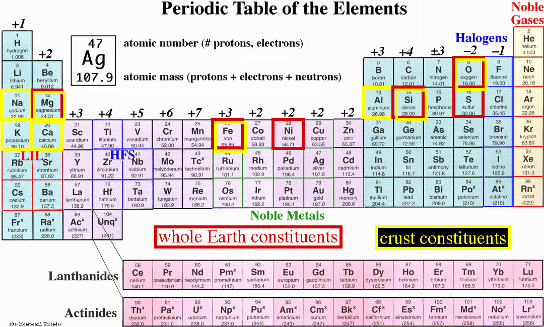
the position of an element in the periodic table relates to the number of electrons in the outer orbital
Atomic Orbital Structures
What elements are important in the Earth?
Elemental composition of the whole Earth and the crust (the outermost solid layer):
| element | whole Earth | crust | atomic number (# of p+ and e-) |
| O |
29 |
46 |
8 |
| Na | <1 |
2 |
11 |
| Mg |
11 |
2 |
12 |
| Al |
1 |
8 |
13 |
| Si |
15 |
28 |
14 |
| S | <3 | <1 |
16 |
| K | <1 |
2 |
19 |
| Ca |
1 |
4 |
20 |
| Fe |
35 |
6 |
26 |
| Ni |
2 | <1 |
28 |
The birth of matter in the universe began about 15-20 Ga, judged by tracing expanding galaxies (groups of stars) back to a common origin in the
Big Bang
After 1 m.y., the universe had cooled sufficiently (3000 °C) for H and He to form from subatomic particles
These elements aggregated to form stars via gravitational attraction; stars are 75 wt% H, 22 wt% He, and 3% heavier elements
The heat of star aggregation caused particles and elements to accelerate and collide, forming elements as heavy as Fe (atomic number 26)
Elements heavier than Fe are produced by during supernovae explosions, which occur when the gravitational force of the outer layers of a star overcomes the thermal pressure of the fusing inner layers
Further accretion formed solar systems, meteorites, and planets by about 4.5 Ga
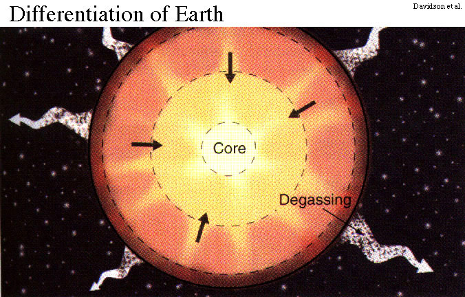
Differentiation of the Earth occurred by gravitational separation of the lightest elements into the atmosphere and the densest elements into the core.
Limbaughium Lb
The heaviest known element. Possesses an ever-expanding mass. Acidic. Emits heat but no light. Instantly polarizes all elements that come in contact with it. Repels protons and electrons; attracts only morons.
3 & 4. The Composition and Structure of Minerals April 4 & 7
Reading: Chapter 2
What is a molecule?
Molecule: group of bonded atoms; e.g., H2O, SiO2,
NaCl
What is a mineral?
Mineral: a solid of specific composition with a regular arrangement of atoms
How do atoms bond together to form minerals?
Elements bond
by sharing or transferring electrons
Why don't elements prefer to remain alone, unbonded?
Elements like to have their outer electron orbital full of electrons, so elements with full orbitals are very stable (e.g., the noble gases
He, Ar, Kr, Xe)
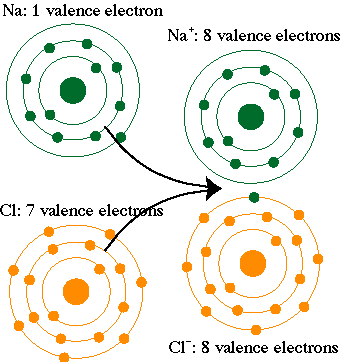
elements near the left side of the periodic table (e.g., K+, Mg2+) like to give up electrons (the next lower orbital becomes full), while those near the right side like to gain electrons to become full (e.g., S2-, Cl-)
ion: an element that has gained (anion) or lost (cation) electron(s)
How do bonds form among alkali metals and halogens?
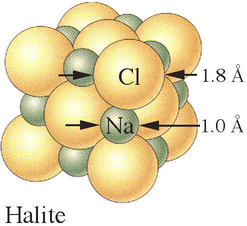
ionic bonds form by the transfer of atoms from an element with an nearly empty orbital (e.g., Na) to an element with a nearly full orbital (e.g., Cl): this bond produces harmless table salt from an explosive metal and a poisonous gas!
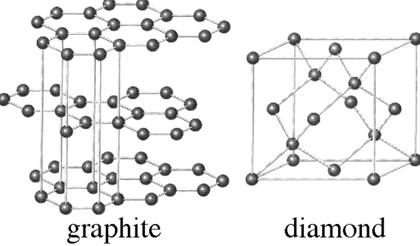
elements in the center of the periodic table (e.g., C, Fe, Ni) with half-full outer orbitals tend to share electrons rather than donate or capture
covalent bonds form by the sharing of electrons among elements with half
full outer orbitals
If Si and O are the most common elements in the outer part of the Earth, what are common minerals made of?
silicates are the most common minerals because O is the most common anion and Si is the most common cation
How do Si and O bond together to form 3-D structures?
Is SiO4 a stable compound?
SiO4 has a net negative charge of 4-; this must be balanced
What structure can be formed from pure Si and O?
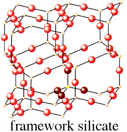
Quartz: SiO2 in a 3-D array of tetrahedra, each of which is joined to other tetrahedra at all 4 corners; quartz is 100% SiO2 and has a density of 2.65 g/cm3
the minimum coordination number for an element that is part of a 3D mineral is IV, thus SiO4, (cannot form 3-D structures from 3-coordinated things like CO3)
Are other structures possible for pure Si and O?
SiO2 can also form other polymorphs, including:
coesite: coordination number = VI, density = 2.92 g/cm3, stable above 2 GPa;
stishovite: coordination number = VIII, density = 4.8 g/cm3, caused by meteorite impacts;
polymorphs: minerals with different structures but identical composition--usually form at different pressures or temperatures
What structures can be formed by adding elements to Si and O?
-
albite, a plagioclase feldspar, NaAlSi3O8, can be formed from quartz via a substitution that maintains charge balance: Si4O8 - Si4+ + (NaAl)4+
albite contains less SiO2 than quartz, 67%, and has a higher density of 2.6 g/cm3
-
anorthite, also a plagioclase feldspar, CaAl2Si2O8, forms by a similar substitution scheme: Si4O8 - 2Si4+ + (CaAl)4+
anorthite contains less SiO2 than albite, 58%, and has a higher density of 2.9 g/cm3
What other common mineral structures exist?
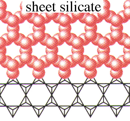
- mica, a platy mineral is composed of SiO4 tetrahedra that share three corners with other tetrahedra; K+ between the layers provides charge balance
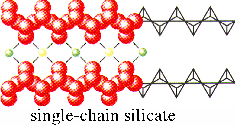
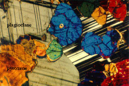
- pyroxene, (Mg,Fe)SiO3, a blocky mineral composed of chains of SiO4 tetrahedra that share two corners; its 2- charge is balanced by an M2+ anion;
pyroxenes have only 50% SiO2 and a density of 3.1 g/cm3
ionic substitution (e.g., Fe <--> Mg) allows wide compositional variation in pyroxene
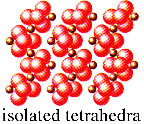
- olivine, (Mg,Fe)2SiO4, is composed of independent tetrahedra balanced by 2M2+ anions; it contains only 38% SiO2 and has a high density of 3.3 g/cm3
note the progressive change from quartz to olivine of decreasing SiO2 content, increasing density, and increasing isolation of SiO4 tetrahedra; these changes play important roles controlling the composition of the Earth, and determining which minerals appear in different parts of the Earth
"If at first you don't succeed, skydiving is not for you."
5. The Formation and Composition of the Earth April 7 & 9
How do pressure and temperature vary within the Earth?
P gradient within the Earth results from density*gravity*depth
T gradient within the Earth results from radioactive heating + cooling from nebular condensation + crystallization of the inner core from the outer cord
Is the Earth the same composition everywhere?
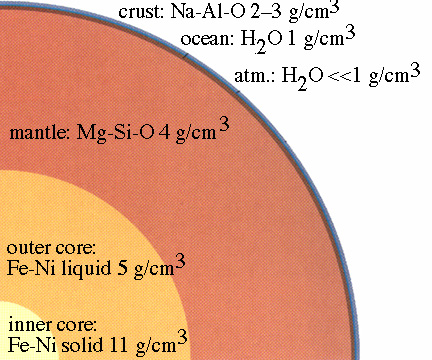
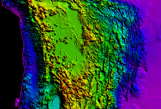
Crust-to-core figure
About 500 Ma after the beginning of the accretion to form the Earth, the temperature and pressure below ~500 km depth became high enough to melt Fe, which enabled this dense metal to sink to the core of the Earth
This gravity-driven movement of Fe toward the core produced additional heat and allowed other elements to melt (e.g., Ni)
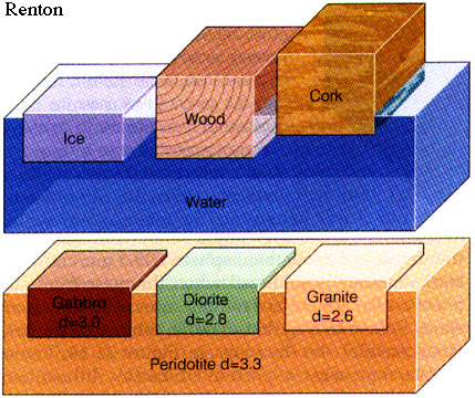
thus the Earth became differentiated, principally by gravity, into a dense Fe-Ni core (11 g/cm3), a Mg-Si-O mantle (3-5 g/cm3) and a low-density Na-Al-O crust (2-3 g/cm3)
If we know the composition of the Earth, what minerals and rocks does it contain?
rock: an aggregate of minerals, glass or rock fragments
| part of Earth | minerals | type | density |
| core |
Fe + Ni minerals |
metallic |
>5 g/cm3 |
| mantle |
olivine + pyroxene |
ultramafic |
>3.3-4.5 g/cm3 |
| oceanic crust |
plagioclase + olivine |
mafic (Magnesium + Ferrum) |
3.0 g/cm3 |
| continental crust |
quartz + feldspar |
felsic |
2.7 g/cm3 |
When two service station attendants in Ionia, Michigan, refused to hand over the cash to an intoxicated robber, the man threatened to call the police. They still refused, so the robber called the police and was arrested.
6. Radionuclides, Radioactivity, and the Age of the Earth April 9
Reading: Chapter 8, pp. 149-157 only
Thursday, April 10, noon: UCSB alumna Nancy Emerson (Superfund Project Manager for Unocal) and associate Rita Rausch (Senior Project Geologist for the company Levine-Fricke Recon) speak on careers in geoscience.
How old is the Earth? (Recall that the universe is 15-20 Ga old)
Radiometric dating of the moon and meteorites indicate that the Earth is 4.6 Ga old
How does radiometric dating work?
isotope: atoms of a single element with the same number of protons, but different numbers of neutrons (e.g., 18O, 17O, 16O, all have 8 protons, but 10, 9, or 8 neutrons)
some (parent) isotopes are unstable and break down to form daughter isotopes at a constant rate of decay
Radioactivity was discovered about 100 years ago by Wilhelm Roentgen and Henri Becquerel, who noticed that uranium, just like sunlight, fogged photographic paper. Marie and Pierre Curie found other elements, like Th, Po, and Ra ("radioactivity" is named after radium), that behaved this way.
two common decay schemes are:
beta decay: a neutron loses an electron, becoming a proton, and radiant energy is expelled in the form of gamma rays; the atomic (proton) number (Z) of the daughter is the parent+1 and the neutron number (N) is the parent-1, but the atomic mass (A = Z + N) does not change (e.g., 4019K -> 4020Ca)
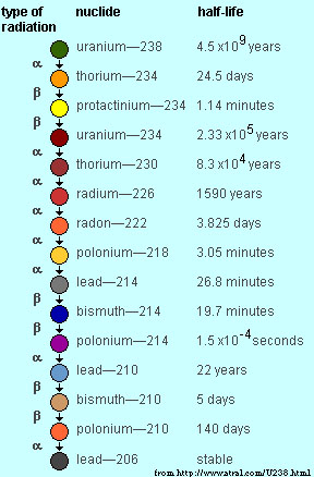
alpha decay: the loss of 2 protons and 2 neutrons that have combined to form He (e.g., 23892U -> 23490Th + 42He)
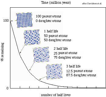
half life, t1/2
, is the time required for half of a parent isotope to be consumed
alpha particle: helium nucleus
beta particle: electron emitted from a nucleus
gamma particle: electromagnetic radiation similar to x-rays
Table of the Nuclides
What radioactive elements exist and which parent-daughter decay schemes are commonly used and for what purposes?
| decay scheme | material | age | half life |
| 14C -> 14N |
organic material |
100-100,000 a |
5730 a |
| 40K -> 40Ar |
felsic crustal rocks |
100 ka to 10 Ga |
1.3 Ga |
| 238U -> 206Pb |
mafic crustal rocks |
1 Ma to 10 Ga |
4.5 Ga |
how old are the oldest minerals on Earth? 4.2 Ga (zircons)
how old are the oldest rocks? 3.8 Ga (sediments)
Geologic time scale from http://icecube.acf-lab.alaska.edu/~fsklb1/geo-time.html
EON | ERA | PERIOD | EPOCH | DATES (Ma) | AGE of
|
| Phanerozoic | Cenozoic | Quaternary | Holocene | 0-2 | Mammals | Humans
|
Pleistocene
|
| Tertiary | Neogene | Pliocene | 2-5
|
| Miocene | 5-24
|
| Paleogene | Oligocene | 24-37
|
| Eocene | 37-58
|
| Paleocene | 58-66 | Extinction of dinosaurs
|
| Mesozoic | Cretaceous | 66-144 | Reptiles | Flowering plants
|
| Jurassic | 144-208 | 1st birds/mammals
|
| Triassic | 208-245 | First Dinosaurs
|
| Paleozoic | Permian | 245-286 | Amphibians | End of trilobites
|
| Carboniferous | Pennsylvanian | 286-320 | First reptiles
|
| Mississippian | 320-360 | Large primitive trees
|
| Devonian | 360-408 | Fishes | First amphibians
|
| Silurian | 408-438 | First land plant fossils
|
| Ordovician | 438-505 | Invertebrates | First Fish
|
| Cambrian | 505-570 | 1st shells, trilobites dominant
|
| Proterozoic | Also known as Precambrian | 570-2,500 | 1st Multicelled organisms
|
| Archean | 2,500-3,800 | 1st one-celled organisms
|
| Hadean | 3,800-4,600 | Approx age of oldest rocks 3,800
|
"Always remember to pillage before you burn."
-->Go to current lecture notes
7. Evaporation, Precipitation and Climatic Belts Fri Apr 11
Reading: Figure 5-6, Chapter 16
What is the water budget of the Earth?
The oceans make up 67% of the surface of Earth
water: 97% in oceans, 2% in glaciers, <1% in atmosphere + lakes + rivers, (excludes H2O in solid Earth)
half the mass of the atmosphere is within 5 km of the Earth and 99% is within 100 km
What controls temperature?
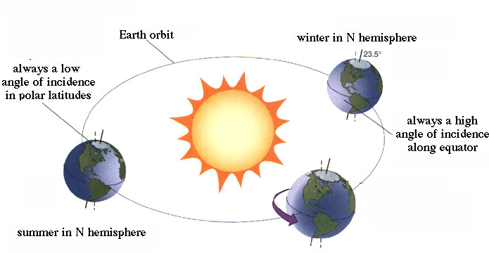
temperature falls nearly monotonically from the equator to the poles because incoming solar radiation is dictated by the incident angle of the Sun's rays
because the equator receives 3X the energy that the poles receive, a temperature gradient exists that drives air from the equator to the poles
of the energy reaching the Earth from the Sun, 20% is absorbed by atmospheric gases such as ozone, CO2, and H2O, 30% is reflected back by clouds, and 10% by the Earth's surface
albedo is the % radiation reflected back; snow is a very good reflector with an albedo of 90, while dense forests reflect only 5% of incoming radiation
the Earth re-radiates energy back into space, but a large fraction is trapped by clouds. This interaction between incoming solar radiation and outgoing re-radiation is similar to a greenhouse
What controls evaporation and precipitation?
temperature and humidity dictate rates of evaporation
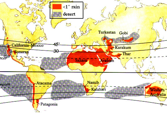
evaporation is high in the tropics, but highest in the desert regions because of the dry winds that blow down upon desert latitudes
rainfall & temperature picture
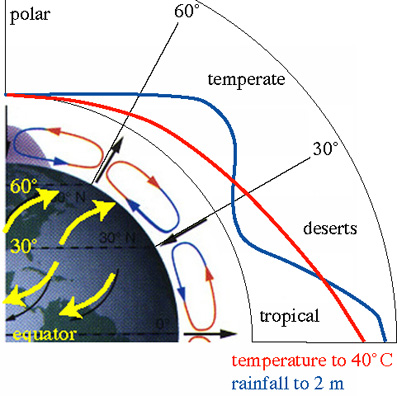
tropics: high rainfall results because rising warm air carries lots of water vapor, which cools quickly and produces torrential rains daily (e.g., Borneo)
deserts (20-30° north and south latitude) have little precipitation because the wet tropical air is dried by raining in the tropics, becomes dense by cooling during rising, and then spreads laterally toward north and south poles, sinking, heating, and scouring desert regions of moisture (the Hadley cell or trade wind cell)
poles/temperature regions have high albedo and little rainfall
What effect does topography have on climate?
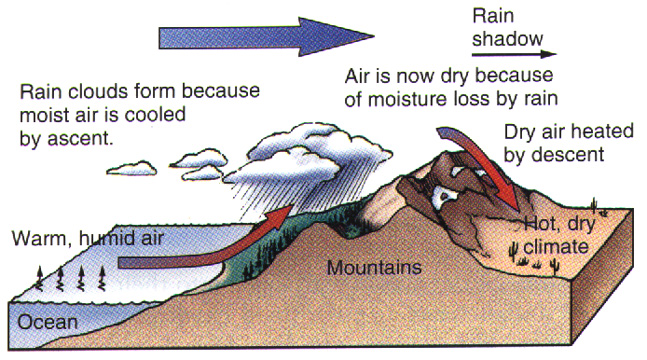
orographic effects; rain shadow of Cascades, Sierra Nevada, Himalaya
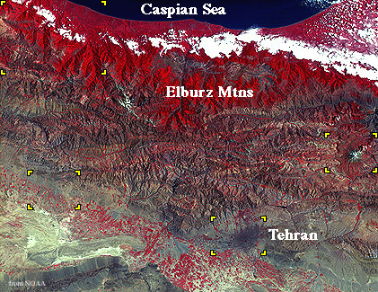
Look at the vegetation signature of the rain shadow in Iran
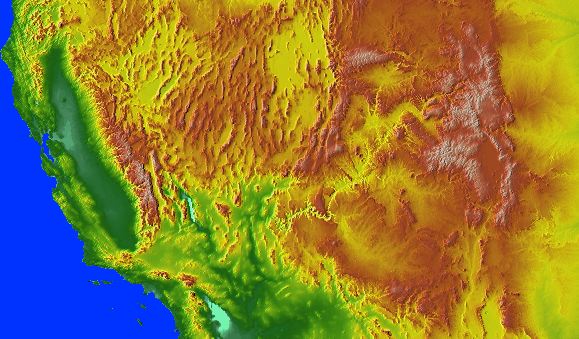
Western US topography suggests a rain shadowWhat effect does climate have on topography?
climate can affect topography by controlling the amount of erosion
e.g., the Himalaya
e.g., the Colorado Plateau
What's going on today?
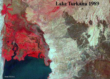
desertification: expansion of deserts (presently 35% of Earth) caused by population explosion is occurring at a rate of 0.1%/yr (i.e., in 40 yr, deserts will cover 39% of Earth): overgrazing, overcultivation, removal of plants for fuel, salinization
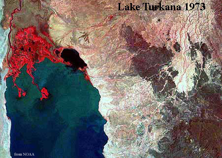
Observe the drying of Lake Turkana from 1973 to 1989
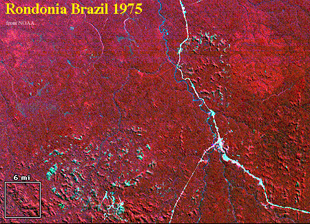
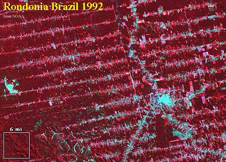
Observe the deforestation in Brazil from 1975 to 1992
"The trouble with doing something right the first time is that nobody appreciates how difficult it was."
8-9. Weathering, Erosion, Sediment Transport and Sedimentary Rocks, Flooding Mon Apr 14 and Wed Apr 16
Reading: Chapters 5 (weathering) & 6 (sediments) & p. 143-149 (time) 13 (floods)
First midterm is next Monday April 21
What constitutes weathering?
weathering: the breakdown of rocks and minerals to form (eventually) soil
What are the two main kinds of weathering?
mechanical weathering: the physical breakdown of rocks into smaller pieces; includes abrasion, frost wedging, expansion and contraction of minerals in response to changes in temperature, exfoliation (expansion of minerals in response to decompression)
chemical weathering: (1) the dissolution of minerals; (2) hydrolysis: the replacement of alkali cations (Ca2+, Na+, K+) by H+, forming clays from feldspars; (3) oxidation: e.g., Fe2+ --> Fe3+ (rusting)
Why be concerned with weathering?
Weathering produces sediment, soil, sedimentary rocks, and these cover the bulk of the land surface.
What is erosion?
erosion: movement of rocks and sediments from high to low areas
the angle of repose is the angle at which granular material rests in equilibrium with gravity
What are the major erosional agents?
the main natural causes of erosion are the three phases of H2O: wind, freeze-thaw cycling, and moving water
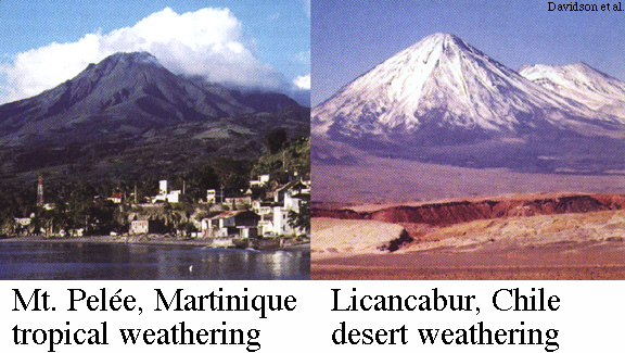
Weathering is very different in tropical vs. arid climates
unnatural causes of erosion are chiefly overbuilding, which concentrates runoff, and off-road vehicles and logging, which not only directly kill plants and animals, but also disrupt soil allowing it to be eroded by wind or water
What's a typical erosional path?
a typical history for a rock: frost wedging and expansion/contraction caused by changes in temperature and pressure cause a rock on top of a mountain to break into smaller pieces; at some point a piece is gravitationally unstable and rolls downhill, breaking into smaller bits, some of which land in a gully; during a large rainstorm one of those bits washes downhill, wearing away as it goes, and enters a stream; in the stream, the particle undergoes chemical alteration and abrasion, eventually becoming clay; that clay is suspended in the stream and carried far out into the ocean, where it settles slowly to the seafloor
What do we call eroded materials?
sediment: a collection of particles, like sand or mud
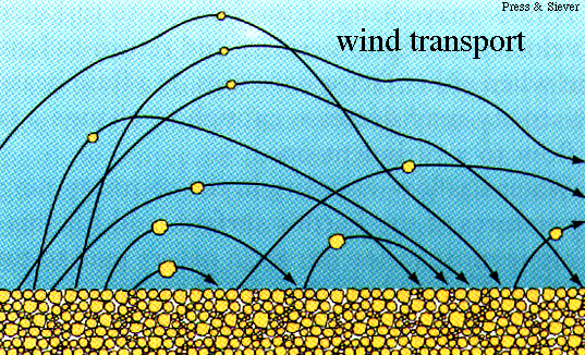
When you look at a sediment, how do you describe it? and How are particles actually transported by water and air?
sorting: the separation of particles based on size, density, or shape
and rounding; i.e., well sorted - poorly sorted
wind is an excellent sorting agent because it can move only small particles
beaches are excellent because they move single particles back & forth many times
rounding: the rounding of sharp edges on particles; i.e., well rounded - angular
rounding is mostly a function of transport distance, with long-distance transport producing well-rounded particles
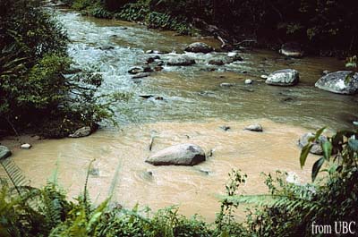
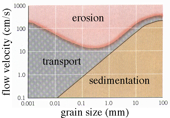
grain size: the size of grains in a sediment or rock; the size of grains in a rock is dictated by the viscosity and speed of the transporting agent (wind, water, ice)
wind moves smaller particles than water
fast water moves bigger particles than slower water
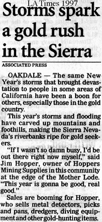
This is most evident from the sudden uncovering of gold nuggets that occurs in the Sierra after a year of heavy rain
| size | name | sediment | environment |
| >1 m | block | 'chaos' | steep slope |
| 1 m | boulder | boulder conglomerate | fast river |
| 1 cm | pebble | pebble conglomerate | high-energy beach |
| 1 mm | sand | sandstone | beach |
| <1 mm | mud | mudstone | lagoon, deep ocean |
deposition: Stoke's law: relation between particle size and settling rate
the energy of the transporting medium not only determines the sizes of the particles that are carried, but also determines the shape of the river; the fast parts of rivers are deep, where particles are swept downstream; the slow parts of rivers are shallow, where particles are deposited
straight, braided streams are formed in areas of steeper topography where rivers move swiftly
curved, meandering streams are formed in areas of minimal topography where streams move slowly
Check out the Grand Canyon
sedimentary rock: lithified sediment or chemical precipitate
bedding: a subhorizontal layer of sediment or sedimentary rock
superposition: the principle that sediment layers are deposited one atop the other; allows you to determine the relative ages of the layers
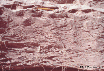
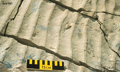
Compare these modern ripples in a sand bank in the Grand Canyon with these fossil ripples in sandstone
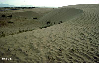
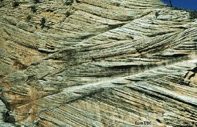
Compare these modern dunes from the Qaidam Basin of China with these fossil sand dunes
What are the environmental aspects of sediment transport?
The main aspect of sediment transport that is relevant to environmental/societal concerns is flooding
Flooding results when a drainage system receives more water than it can handle; a typical case would be unusually high rainfall produces flash floods in mountainous areas, which move downstream, breaching levees and flooding the flat areas that surround rivers
You can observe stream flow records for anywhere in the US at the U.S. Geological Survey Water Resources Division
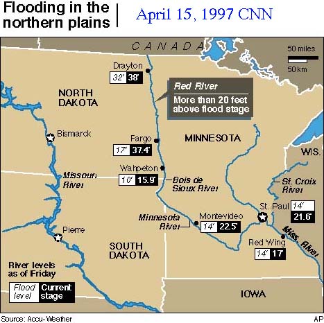
The effects of recent flooding in the midwest can be seen at this 1997 flood server , or on these maps of Minnesota and and the Minnesota area
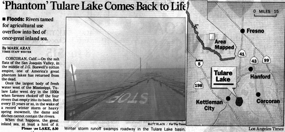
Check out the January 1997 resurrection of Tulare Lake in central California
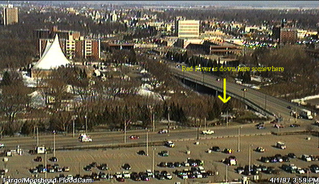
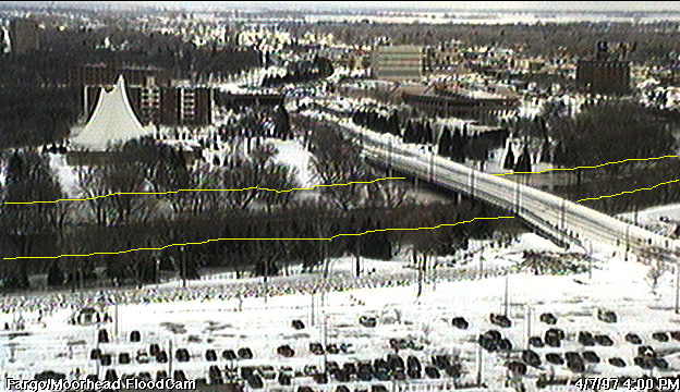
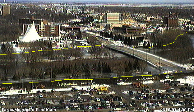
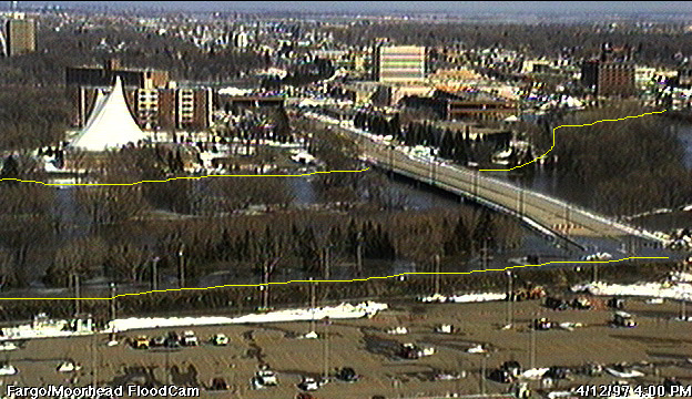
A nice sequence of images of the Red River in Fargo North Dakota showing the ongoing floods of April 1997:
April 1, 1997
April 7, 1997
April 10, 1997
April 12, 1997
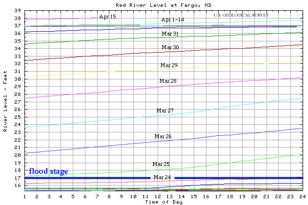
This river level chart shows the rising Red River in the last month
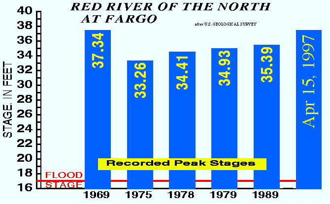
Look at the recent historical record of floods at Fargo; care to build a home here?
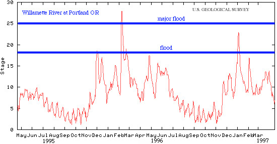
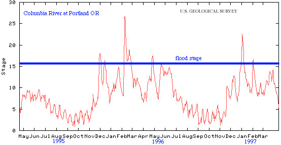
Similar stream flow records for the Willamette and Columbia Rivers at Portland OR show the seasonal, episodic nature of streamflow and flooding
How serious an issue is flooding from a human perspective?
-
July 6, 1996: flooding along the Yangtze River: 600 killed, 33,000 injured
-
Aug 7, 1996: flash flood in the Pyrenees killed 70 in campground
-
Aug 10, 1996: flooding in Liaoning province 100 killed 4,500 injured--affected 100 M people
-
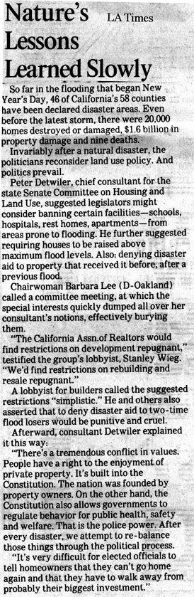
January, 1997: flooding in Washington, Oregon, and central California caused huge amounts of damage--some homes were underwater for a month!
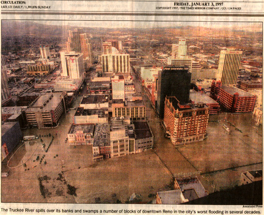
- January, 1997: flooding in Reno caused by the Truckee River
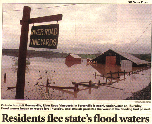
- January, 1997: flooding of the Russian River
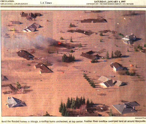
- January, 1997: flooding of Marysville by the Feather River
But, there are still people who do not understand; the local SB News Press ran an article showing a Sacramento developer standing in mud after the 1997 central CA floods saying that he could still build in a flood plain
Problem: urbanization causes precipitation to run quickly instead of slowly into rivers
Geological solution: do not allow building in flood-prone areas
Political solution: none, because restriction of building is politically unpopular with most people and certainly is unpopular with developers
Fiscal solution: insurance companies will eventually realize that it is stupid to insure people whose homes or businesses are going to wash away
What can you do?
- guess (most popular)
- hire a geologist (required in some areas)
- look at a flood-hazard map (good idea)
- become a geologist and evaluate the situation yourself
don't buy a house if the land has rounded boulders--the bigger the boulder, the bigger the flood!
"It may be that your sole purpose in life is simply to serve as a warning to others."
10. Groundwater Hydrology and Drinking Water
Reading: Chapter 14
Friday, April 25, noon: Mark Grivetti and Brian Locke, Engineering Geologists with Dames & Moore talk about what they do for a living as geotechnical geologists.
USGS Water Resources
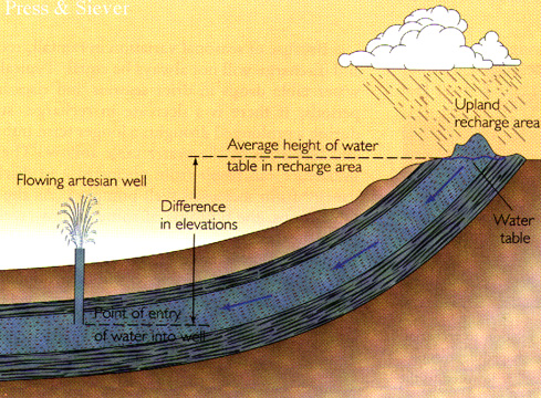
groundwater: water stored in porosity in the Earth
porosity: pore space (holes, voids) in rocks and sediment
Where does groundwater come from?
groundwater originates where rainwater, lakewater, and riverwater percolate into the ground
the water table is the surface below which pores are filled with water
an aquifer is a porous volume of rock containing flowing groundwater
So how does groundwater ever come out again?
groundwater is pumped to the surface with wells, but it also comes to the surface naturally as springs
the hydraulic head built by the difference in elevation between the source of the water and the outflow drives groundwater flow
the water flows through the porosity in the rocks and sediments
the rate of flow is determined by the permeability of the rocks or sediments, which is the ease by which fluid can flow through a rock or sediment
How big are aquifers?
there are aquifers that extend across half the width of Australia
How fast does water move through aquifers?
water moves through aquifers at rates of 1 mm --> 100 m/day (compare to streams!)
How much time does it take for water to flow through an aquifer?
14C dating shows that some groundwater percolated into the Earth as long ago as 10 ka!
How important is groundwater to humans?
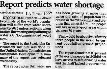
0.6% of all water in/on/around the Earth is groundwater, yet it supplies >50% of all drinking water
Is there enough groundwater?
consumption of groundwater in the US has doubled from 1955 to 1985
some areas have major droughts--periods of insufficient water--and this is predicted to worsen
Here in SB we built a desalinization plant and then became tied to the state water system after the local reservoirs were judged insufficient.
But, look at the incredible costs of this:
Water Costs for the City of Santa Barbara
(source: Bill Ferguson, Water Supply Planner 15-Apr-97)
| procedure | cost per acre-foot |
| Old water from Bradbury Dam/ Lake Cachuma ~1953-1995 | $34 |
| 1996 re-negotiated amortization schedule paying for dam construction | $185 |
| de-sal plant cost $34 million amortized over 5 years (original plan) | $1900! |
| de-sal amortized over 20 years (if re-negotiated) | $1250!! |
| State water pipeline cost of construction $40-50 million amortized 25 to 35 yr. | $1400!!! |
*one acre-foot = 1 foot deep over an area of 1 acre = water used by 3 to 4 Santa Barbara families
in 1 year.
In other parts of the country a family uses about 1 acre-foot per year.
Costs of water include construction, payment to the source(State water), delivery,
maintenance, administrative costs and treatment.
Lompoc in the North County pays $700/acre-foot mostly for treatment of high dissolved solids in groundwater that infiltrates from the Santa Ynez River below Bradbury Dam.
Residents of Solvang are angry about the state aqueduct.
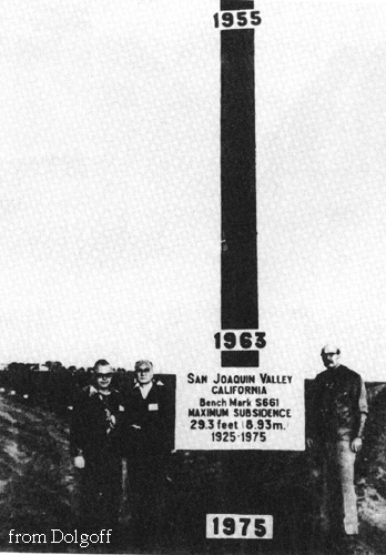
when groundwater, oil, or gas are pumped from the ground faster than they can be replenished, the ground surface may subside or, near the ocean, salt water or other pollutants may be drawn into an aquifer
in the San Joaquin valley of central CA the ground has subsided more than 8 m
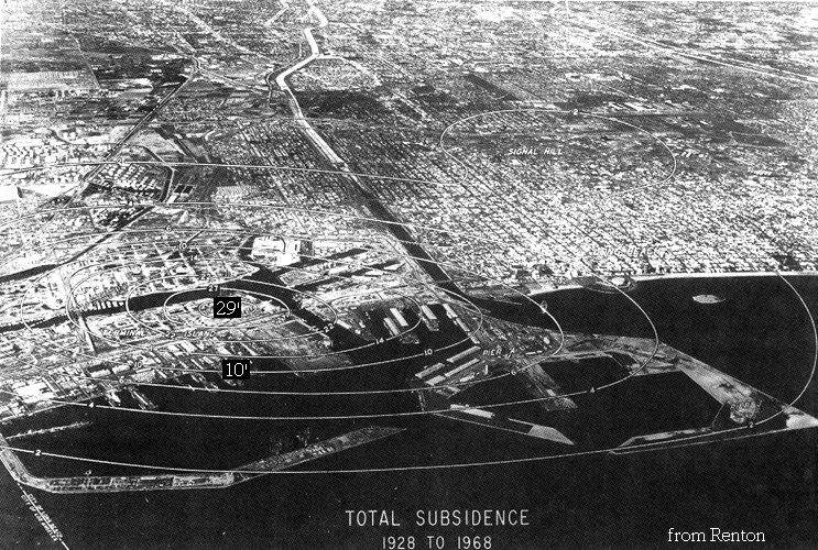
by 1940, pumping of oil from beneath Long Beach caused the ocean to begin flooding parts of the land; by 1975 some areas had subsided 10 m; the subsidence was stopped or reversed when people began pumping water into the ground while removing oil
What are the main societal concerns about natural processes affecting groundwater quality?
elements introduced into groundwater by natural processes can affect water quality substantially:
for example, irrigation water derived from rivers of the Coast Range was collected in Kesterson Reservoir from 1975-1985; the discovery of dead and deformed birds prompted an investigation by geologists, who found 4000 ppb Se in the water (the EPA limit for Se is 10 ppb); Se is derived from the weathering of volcanic rocks and was concentrated in the reservoir
the physiological reasons are not understood, but studies have shown an increased risk of heart disease from water with SO4 and a decreased risk from water that contains Mn + Cr + V + Cu
Can earthquakes affect our supply of water?
What are the main effects that humans have on groundwater quality?
the biggest destroyers of groundwater are feedlots, pesticides, leaking tanks, sewage, and salt and lead washed from snow/ice-covered streets
Love Canal was built near Niagara Falls in 1892, filled with chemical wastes until 1953, and then covered and had homes built over it; heavy rains in 1976 caused toxic materials to surface, killing plants, eating rubber shoes and tires, and causing health problems in local residents
Problem: aquifers are emptying and groundwater is becoming polluted
Geological solution: build more reservoirs and stop dumping toxic compounds
Practical solution: ? reservoirs are expensive
"The law of Probability Dispersal decrees that whatever it is that hits the fan will not be evenly distributed."
11. Caves and Karst (guest lecturer Joel Despain from SequoiaĐKings Canyon National Park) April 25
Reading: Chapter 14
caves are one of two real frontiers remaining to humans; the other is the deep sea
most significant caves are in limestone
How is limestone produced?
limestone: sedimentary rock, CaCO3, formed chiefly by the accumulation of dead open-ocean animal shells and skeletons
acidic groundwater forms by the decomposition of organic material and then dissolves limestone
the dissolution of limestone occurs first along fractures, then underground rivers and lakes develop along with surface sinkholes; finally, tower karst forms
Why does Florida have so many sinkholes?
What are the main ways humans impact caves?
caves are threatened by logging, which fills them with mud; by groundwater pollution, which changes the rate of dissolution or kills animals in the cave; and by mining for concrete
12. Coastal Processes, Surfing and Drowning April 28
Reading: Chapter 19
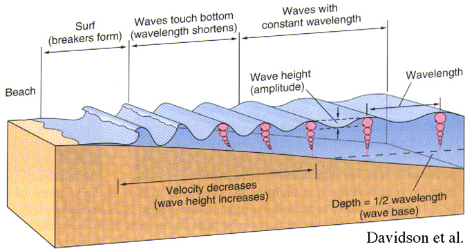
What is a wave?
Regular variation with a frequency (time between peaks), an amplitude (peak-to-trough height), and a wavelength (distance between peaks)
What makes waves?
Waves form primarily from the motion of wind over the surface of the ocean
You can often observe a short wavelength, high amplitude set of waves generated nearby, superimposed on a long wavelength, low amplitude set of waves generated somewhere across the Pacific
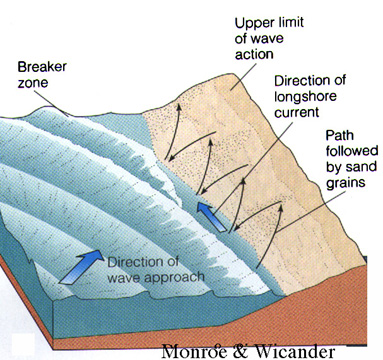
Why do waves 'break'?
As a wave approaches a beach and reaches shallow water, its bottom slows because energy is expended moving sediment along the seafloor; this causes waves farther offshore to bunch up, shortening their wavelengths and increasing their amplitudes; slowing of the bottom of the wave also causes the wave to steepen and eventually fall
What effects to waves have on beaches?
longshore drift, the motion of sand parallel to the coast, results from the oblique convergence of waves with shoreline
it produces spits, baymouth bars (forming lagoons, like the one on campus)
1.5 million tons/year sand pass by Oxnard under the influence of longshore drift
low energy summer waves carry sand into shallow water and build beaches; high energy winter waves take sand from beaches and move it into deeper water
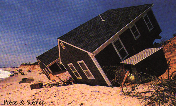
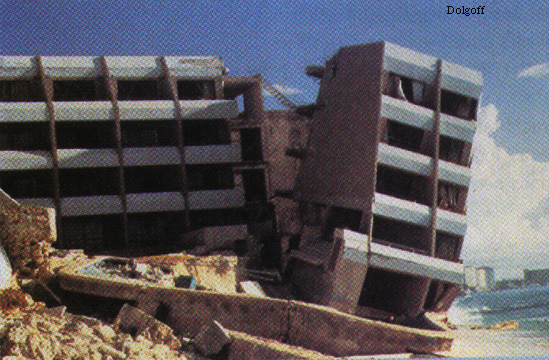
What relevance do beaches and longshore drift have to society?
Problem: people like to have homes on cliffs overlooking beaches, but the beach is a high energy environment that destroys homes. People also like beaches with a lot of sand and harbors with no sand, so they build seawalls, breakwaters, groins, jetties; unfortunately, people also build dams, reducing the amount of sand transferred from rivers to beaches, resulting in undernourishment
Geological solution: don't build dams and don't build houses on cliffs near the ocean; Ask yourself "Why is there a cliff at the beach in the first place?"
Practical solution: Minimize impact and hope for the best--coastal processes are so much bigger than humankind's possible efforts
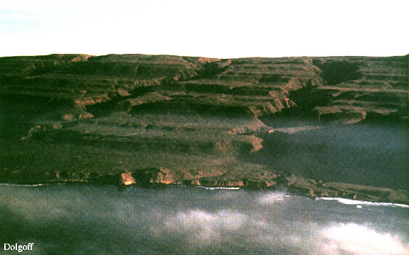
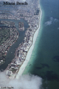
Is the beach here in California typical?
its uplifted terraces and dentate coastline are characteristic of tectonically active areas
the western Canada coast has drowned glacial valleys
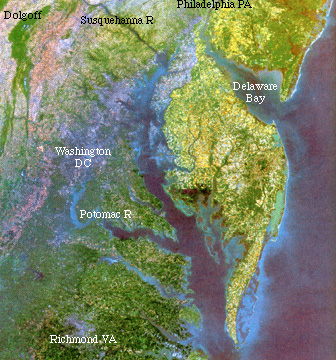
the east coast of North American has drowned river valleys
Florida is a flat carbonate shelf
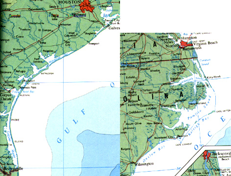
the eastern and southern US have lots of barrier islands
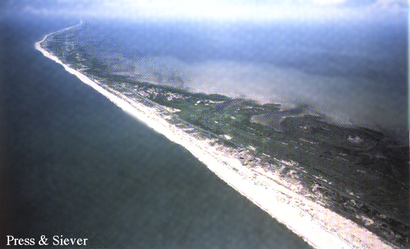
What are barrier islands anyway?
barrier islands: <6 m high!, <100 km long!, <5 km wide
form by longshore drift or piling up of sand from deeper water
So what? Why should I care about barrier islands?
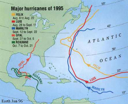
the worst natural disaster (in terms of lives lost) in North America was a category 4 (300 kph winds) hurricane in 1900 that drowned 6,000 people!
Tracks of Atlantic hurricanes in 1995
Nov 7, 1996 cyclone killed 2,000 people along the SE coast of India
What does the future hold?
climatic variation causes cyclicity: from 1970-1994, an average of 4 major hurricanes hit the east coast every year, but from 1945-1970, the average was 16!
What relevance do barrier islands have to society?
Problem: relative paucity of hurricanes in the last 25 years has caused people to build on gentle land near the coast and on barrier islands
Geological solution: stop building on barrier islands; but also we are killing reefs, which protect the Florida coast, for example, with toxic compounds (e.g., gasoline, fertilizers, sediment), which cause the reef to die and erode
Political solution: none? politicians are in developer's pockets
Fiscal solution: insurance companies will eventually realize that it is stupid to insure people whose homes or businesses are going to wash away; tourism industry may realize that poisoning reefs is bad business
"There is absolutely no substitute for a genuine lack of preparation."
"Indecision is the key to flexibility."
13. Glaciation and Noah's Ark
Reading: Chapter 15
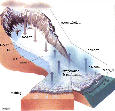
What is a glacier?
glacier: moving ice body covered with rocks
glaciers form when snow accumulates faster than it melts
weight causes downhill flow
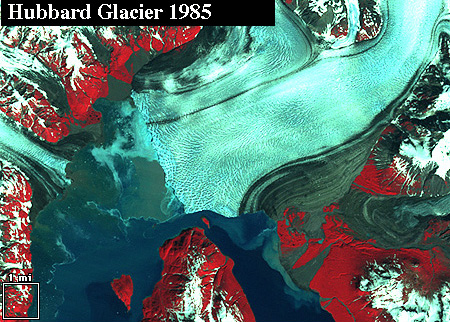
Observe the movement of the Hubbard Glacier from 1985to 1986
Because ice is so different from unfrozen water, what effect do glaciers have on sediment transport?
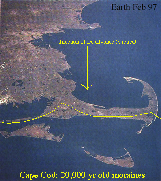
moraines: sediments deposited by glaciers become till: Cape Cod
erratics are boulders transported by glaciers that have been left behind after retreat of the glacier
Because ice is so different from unfrozen water, what effect do glaciers have on the Earth surface morphology?
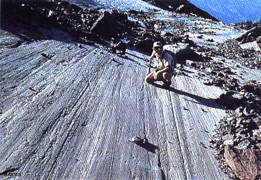
glacial polish: a polished surface formed by a glacier moving ice and sediment over solid rock
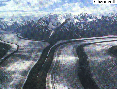
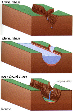
glaciers produce U-shaped valleys, in contrast to the V-shaped valleys produced by rivers
fjords: drowned glacial valleys
glaciers also produce hanging valleys, drumlins, and roche moutonné (e.g., Lembert dome in Tuolumne Meadows)
There are two kinds of glaciers: alpine glaciers and continental glaciers
alpine glaciers: mountain-scale glaciers caused by low temperature and more precipitation than melting
Where are the nearest alpine glaciers?
The nearest alpine glaciers are on Mount Shasta and in the Palisades area of the Sierra Nevada
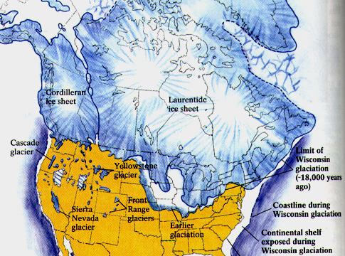
continental glaciers: continent-scale glaciers caused by global cooling, which may be caused by tectonics or Milankovitch cycles (variations in the Earth's position and orientation relative to the Sun)
Where are continental glaciers today?
The main continental glaciers of the present are the Arctic (over water), Antarctic (over land), and Greenland
today glaciers cover 10% of Earth
the Antarctic ice sheet is 1.5X the size of the continental US
What happens if the climate of the Earth is cooler?
ice age: period of Earth history (usually 10's of Ma) when there were lots of large-scale glaciers
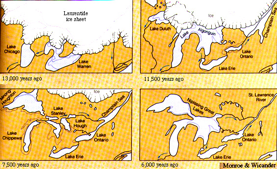
18 ka ago ice covered 30% of Earth; extending down the Mississippi River Valley halfway from Canada to the Caribbean (S. Illinois)
it created the Great Lakes & Finger Lakes
Ice ages have occurred throughout geologic time, and are caused by 1) 26,000-year cyclical precession of Earth's rotation axis, 41,000-year cyclical changes in tilt of Earth's rotation axis, and 100,000-year cyclical changes in the eccentricity of Earth's orbit; 2) 11- and 22-year cycles in solar activity; 3) volcanic eruptions; 4) atmospheric gases; 5) positions and heights of mountain ranges; 6) positions and shapes of continents.
The Chico, California, City Council enacted a ban on nuclear weapons, setting a $500 fine for anyone detonating one within city limits.
14-15. Earthquakes, Faults, Seismic Hazards: May 2 & 5
Reading: Chapters 9 and 10
What produces mountains?
orogeny (mountain building): takes place by the folding and faulting of rocks
folds are bends in rocks
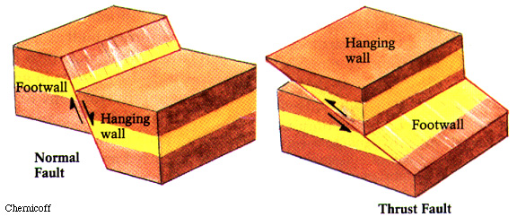
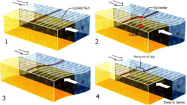
faults are planar surfaces along which the rocks on both sides have been displaced with respect to each other
What kinds of faults are there?
in a normal fault, the rock above the fault moves down relative to the rock under the fault (e.g., the Owens Valley fault)
in a reverse fault, the rock above the fault moves up relative to the rock under the fault (e.g., the Malibu Coast fault)
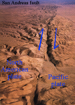
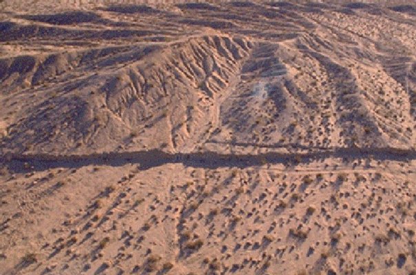
in a strike-slip fault, the rock on one side of the fault moves sideways relative to the rock on the other side of the fault (e.g., the San Andreas fault)
How do you recognize a fault?
active faults have scarps, which are visible offsets of the ground surface
inactive faults may be recognized by the juxtaposition of unlike rock types or the offset of distinctive rocks; e.g., the volcanic rocks that form the Pinnacles National Monument near Salinas were offset 200 km northward from the Neenach Volcanics along the Grapevine
What happens when a fault moves?
earthquakes occur when faults move
What causes earthquakes or what causes faults to move?
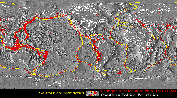
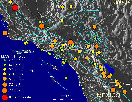
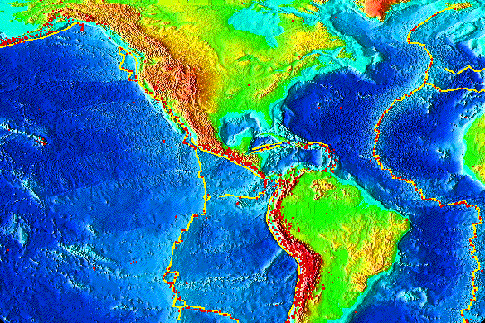
energy that accumulates in the Earth as a result of plate tectonics may be released as earthquakes; the locations of earthquakes worldwide are clearly related to tectonic plate boundaries; at a smaller scale (see examples of southern California major events and all seismicity from 1932-1996) earthquakes are related to known faults.
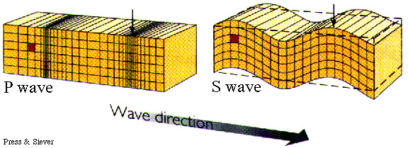
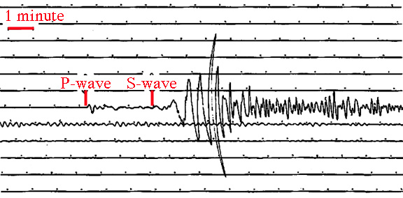
How does the energy released in an earthquake travel through the Earth?
earthquake energy travels at km/s as compressional ('P') or shear ('S') waves
it is recorded by seismometers, which may produce a seismograph of the motion of the seismometer produced by the waves
the focus of an earthquake is the initial point of rupture
the epicenter of an earthquake is the point on the surface of the Earth directly above the focus; the epicenter is of more interest to non-geologists than the focus because it is on the surface of the Earth, where humans live
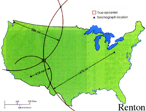
How do geologists locate earthquake epicenters?
epicenters can be located by comparing the times at which S waves arrive at different seismometers
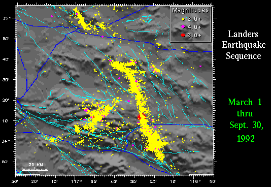
Look at the epicenters for the Landers earthquake.
an aftershock is a smaller earthquake that occurs after and in the same area as a larger earthquake
View the aftershocks of the Northridge earthquake in map view and in cross section.
a foreshock is a smaller earthquake that occurs before and in the same area as a larger earthquake
View the sequence of seismic events of the Big Bear - Landers earthquake sequence.
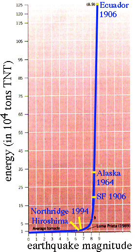
the Richter scale correlates the amplitude of a wave recorded on a seismograph to the amount of energy released during an earthquake
each unit on the Richter scale is an increase in amplitude of 10X and an increase in energy of 30X!
But how much energy do earthquakes actually release?
the magnitude 8.4 Alaska quake of 1964 released 1000 megatons of energy (compare to nuclear warhead)
View the energy release of the Landers earthquake in map view and in cross section.
How much damage/death do earthquakes cause?
the Northridge earthquake of Jan 17, 1994 was a magnitude 6.7 that lasted 40 seconds; it killed 61, destroyed 9 freeways, left 3.1 M people w/o electricity and 40 k w/o water; not the 'Big One'
Tangshan earthquake of 1976 mag 8.0 killed 650,000 and injured 780,000
What kinds of damage do earthquakes produce?
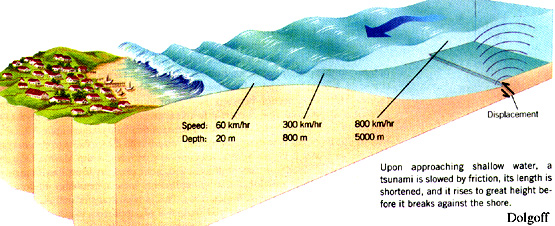
earthquakes cause structural collapse, liquefaction, tsunamis, fires, dam collapses or overspills (dams are often located along faults)
on Feb 17 1996 a magnitude 8.1 earthquake caused a 7 m tsunami to strike the island of Biak, killing 107 people and carrying 3000 homes into the ocean
Can earthquakes be avoided or predicted?
earthquakes cannot necessarily be avoided, but there are certainly areas where they are more common
the New Madrid earthquake (p. 190) occurred in the middle of the continent and was supposedly predicted by the indian war chief Tecumseh who led the Indians to attack the Europeans in the War of 1812
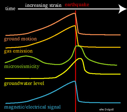
earthquakes can be predicted in favorable circumstances using changes in discharge of water or gas, tilting of Earth's surface, or increased microearthquake activity
How is earthquake frequency assessed?
geologists determine the time between earthquakes by trenching across faults and determining the ages of faulting events
Los Angeles is predicted to have a magnitude 8 earthquake (with 11 m of displacement) every 160 years
magnitude 7 quakes are known to occur in LA every 30 years
So, do the magnitude 7 earthquakes do anything to relieve the energy accumulating along the San Andreas?
in 160 years, each of the 5 magnitude 7 earthquakes will relieve 1/30 of the energy, for a total of 1/6; so LA will still get an earthquake that is 6X as violent as all the energy released in all of the magnitude 7 earthquakes; remember that Northridge was magnitude 6.7!
Are there faults near UCSB?
faults are located along the base of the Santa Ynez Mountains and along the Santa Barbara Channel islands
Will you be hurt/suffer damage during an earthquake? How can you evaluate seismic hazard?
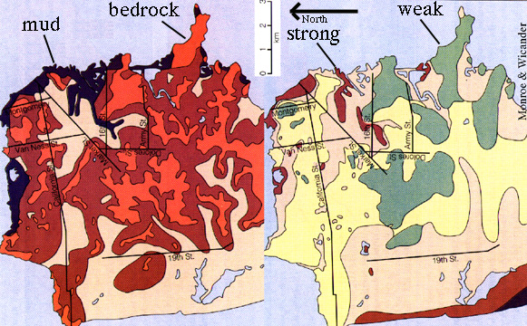
the major factors that cause damage during earthquakes are hillslopes, soft sediment (such as bay fill), and proximity to faults
you can avoid damage by living on level ground, on bedrock, and away from faults (check a geologic map)
Problem: How can we minimize death and damage during earthquakes?
Geological solution: learn how to predict earthquakes
Political solution: ?
Practical solution: stop building on steep slopes (think of home in the hills here), on soft sediment (such as the wharf area here), and on faults (look at the area around Palmdale)
A man in Johannesberg, South Africa, shot his 49-year-old friend in the face, seriously wounding him, while the two practiced shooting beer cans off each other's head.
16. Landslides: Buried Alive
Reading: Chapter 12 April 14
What causes landslides?
landslides, downslope movements of rock/sediment, can occur when a slope is steeper than the angle of repose
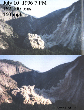
Landslide in action at Yosemite's Glacier Point
the angle of repose is the angle at which granular material rests in equilibrium with gravity
landslides often are triggered by earthquakes, by the introduction of water into porous rock/sediment, or by undercutting at the bottom of a slope, or by removal of vegetation
How fast do landslides travel?
landslides move at speeds up to 200 kph
they may fly over obstacles, as shown by the undamaged pockets of bushes that are sometimes left in areas where a landslide has traveled
landslides can also move very slowly, at the rate of mm/yr
How much damage/death do landslides cause?
30,000 people were buried in earthquake-triggered landslides in mountainous parts of Peru in 1970
you may think stupid things don't happen in the US, but the St Francis dam (a chunk of which is outside the Webb building that houses the Geology Department) on San Francisquito Cr near Saugus California collapsed on Mar 12, 1928, releasing a huge flood that killed 500 people and caused $10 M in damage; the problem was that the dam was built on porous rock
How can you spot a landslide (e.g., when buying a home)?
visible features of landslides include hummocky topography, a scarp at the top, buckled roadway at the bottom of a slide, collapsing roadway at the top of a slide, water leakage indicating spring or seep, tilted powerpoles or trees, cracks or offsets in human-built structures
Are there other things to watch for if none of these warning signs are present?
landslides might occur in areas with steep bedding (here in SB), unconsolidated soil, recently removed vegetation
Problem: roads and buildings are affected by landslides
Geological solution: don't build on unstable ground
Fiscal solution: insurance companies will eventually realize that it is stupid to build in unstable areas
"An expert is nothing more than an ordinary person away from home."
17. Melting and Plutonic Rocks May 16
Reading: Chapter 3
Pluto: Greek god of the underworld
magma: molten rock
Why do rocks melt?
rocks melt because they get too hot or too wet: minerals gain vibrational energy to the extent that they loose structure
plutonic rocks form from magma solidified slowly underground, this slow cooling causes them to be coarse grained
crystallization occurs as tiny nuclei form and then crystals grow around the nuclei
What kinds of magmas and plutonic rocks exist? How hot are magmas?
the SiO2 vs. the MgO+FeO content determines types of magma:
| magma | composition | formation temperature | viscosity | plutonic rock |
| felsic |
>70% SiO2 |
700 °C |
viscous |
granite |
| mafic |
50% SiO2 |
900 °C |
fluid |
gabbro |
| ultramafic |
<40% SiO2 |
1100 °C |
very fluid |
peridotite |
How would you recognize each of these plutonic rock types?
-
granites are pale colored and contain chiefly quartz and feldspar
-
gabbros are dark colored and contain chiefly pyroxene and feldspar
-
peridotites are green colored and contain chiefly olivine and pyroxene
How big are plutons?
plutons, discrete bodies of plutonic rocks, range from a small as building
sized to as large as mountain-sized
"Age is a case of mind over matter. If you don't mind then it really doesn't matter."
18. Volcanoes and Volcanic Eruptions: Burned Alive May 19 and 21
Reading: Chapter 4
Vulcan: Roman god of fire
volcanic rocks form from magma solidified quickly aboveground, this rapid cooling causes them to be fine grained or glassy
| plutonic rock | volcanic rock |
| granite |
rhyolite |
| granodiorite |
andesite |
| gabbro |
basalt |
How would you recognize each of these two volcanic rock types?
rhyolites are pale colored and contain chiefly quartz and feldspar and glass
basalts are dark colored and contain chiefly pyroxene and feldspar and glass
pahoehoe is ropy textured, low viscosity basalt that flows rapidly
a'a is blocky textured, higher viscosity basalt that flows slowly
pillow lava is lava erupted underwater; rapid cooling causing extrusion into tubelike shapes
Do the different types (compositions) of rock produce different kinds of volcanoes?
mafic volcanoes tend to have gentle slopes because of the fluidity of the lava and are called shield volcanoes (e.g., Hawaii)
intermediate composition volcanoes tend to have steep slopes and are called stratovolcanos (e.g., Mt Shasta)
calderas are circular collapsed features (e.g., Crater Lake)
felsic volcanic rocks, because of their high viscosity, more commonly form small domes or erupt as pyroclastic material, which forms the rock tuff
why the difference in danger between rhyolite and basalt? viscosity and volatile content
How large are volcanoes?
volcanoes are generally 10-50 km in diameter and <4 km tall
volcanoes such as Hawaii are 600 km in diameter and <9 km tall
How long do volcanoes last?
most volcanoes are active for 1-10 Ma
volcanos are considered to be active, dormant, or extinct, depending on the length of time since their last eruption
What kinds of threats do stratovolcanoes pose?
stratovolcanoes may cause tsunamis, hot ashflows, and mudflows
underwater explosions may cause tsunamis
At 10:02 on Aug 27 1883, people on the west coast of Java heard a loud boom. 35 minutes later a 30! m wave was visible offshore; it killed 32,000 people!
What they heard was the upper 1000 m of the island of Krakatau being blown into the air. This eruption released 100 MT of energy and reduced global temperature by 1°C
hot, high-speed pyroclastic flows called nuee ardente are very dangerous: in 1902 30,000 people were toasted by the volcano on the island of Martinique;
lahars (Indonesian term!), mudflows released by volcanoes, are reasonably common
a lahar from Nevado del Ruiz volcano in Colombia buried 23,000 people in 1985;
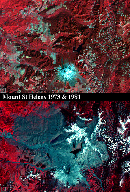
the Mount St Helens eruption moved at 400 kph and moved 28 km also blowing down many trees; I love the story about the Mt Adams climbers 50 km away who were bombarded with blackened pinecones during the Mt St Helens eruptions
a description of the Mount St Helens lahar by a geologist: "It was very noisy...400 m across and flowing 5-10 m/s...it was muddy brown and carrying a lot of debris, some of it white hot. Huge boulders were floating in it. It was like a flowing river of concrete."
What kinds of threats do basaltic shield volcanoes pose?
basaltic shield volcanoes are pretty benign because they are nonexplosive; occasionally, however, they have absolutely catastrophic enormous landslides
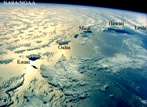
105 k yr ago the west slope of Mauna Loa collapsed, spreading debris for 240 km across the ocean floor; these events are common in the geologic past--the circular island of Kauai was made up of 3 volcanoes.
How close should you live to a volcano?
Mt Rainier is 90 km from Seattle and 65 km from Tacoma; it is considered the most dangerous volcano in the US because of its large size, frequent earthquakes, active hydrothermal system, and extensive glaciers; when a lahar occurs, it is expected to reach the first town, 30 km away, in 45 minutes; the geologic record shows very large lahars every 500-1000 yr
Other dangerous volcanoes
- Mt Baker and St Helens in WA
- Mt Hood, OR
- Three Sisters, OR
- Newberry Crater, OR
- Shasta, CA
- Medicine Lake, CA
- Lassen, CA
- Long Valley (Mammoth), CA
Problem: volcanoes are dangerous--how can we protect people and property?
Geological solution: monitor volcanoes for changes in seismicity, ground surface changes, and changes in gases (SO2, CO2) emanating from the ground: Mammoth CO2 killing trees/'Scenic' escape route
Practical solution: insurance companies
"One-seventh of life is spent on Monday."
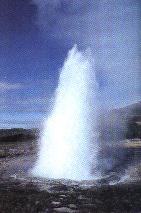
19. Geysers and Hotsprings: Boiled Alive May 23
Chapter 14
What causes geysers, fumaroles, hot springs?
water heated by magmatic or geothermal heat flows toward the surface because of reduced density
the episodicity of geysers is related to sudden changes in water volume caused by changes in pressure
What formed Mammoth Hot Springs?
dissolution and precipitation of carbonate
what are some nearby hot springs you can visit?
Yellowstone, Lassen, Sierra, Tassajara, Bishop
"The facts, although interesting, are usually irrelevant."
20. Precious Metals and Gems May 23
resources: mining & effect on environment
What are some common precious metals or gems mined from the Earth, how are they formed, and where are they found?
| material | source |
| Fe |
banded iron formations |
| Pt |
layered igneous complexes |
| Hg |
volcanic exhalations |
| diamond |
volcanic exhalations |
| Au |
volcanic or sedimentary rock |
| Ag |
sedimentary rocks |
| Cu |
volcanic rocks |
| cubic zirconia? |
laboratory |
what sort of pollution is associated with such mining?
hard-rock mining often produces acidic water; changes in topography; removal of soil and vegetation; and air pollution
"Money can't buy happiness. But it sure makes misery easier to live with."
21. Metamorphism May 23
Reading: Chapter 7
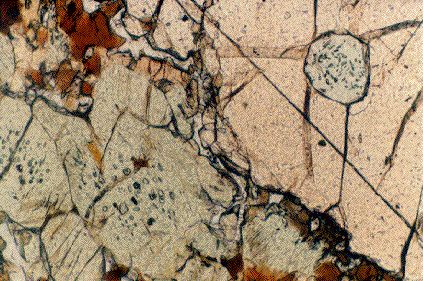
What are metamorphic rocks?
metamorphic rocks are rocks recrystallized under pressure and/or temperature
metamorphism is the process of change under pressure and/or temperature
So who cares about metamorphic rocks?
metamorphic rocks make up >99% of the Earth
What produces heat in the Earth? Why is it hot down below (other than Satan)?
the temperature increases as a result of residual heat from Earth accretion and from the decay of radioactive atoms
the temperature at the solid core of the Earth is 7600 °C
What kinds of changes occur with increasing temperature?
heat causes dehydration of rocks and minerals
for example, clays stable at low temperature contain 10-20 wt% water; with increasing temperature they change to micas with 5 wt% water and then to feldspars with 0 wt% water
heat causes mineral grains to grow larger; e.g., limestoneÆmarble
What produces pressure in the Earth?
pressure increases as the result of the weight of overlying material
the standard pressure, 1 atmosphere, is the pressure of the atmosphere on the surface of the Earth
P = rho * g * z
10 km beneath the ocean the pressure is 1000 atm
10 km beneath the Earth the pressure is 3000 atm
What kinds of changes occur with increasing pressure?
pressure causes minerals to become denser
minerals become denser by adopting smaller cations or increasing the coordination number of bonds
the PT stabilities of minerals of the composition Al2SiO5 are a simple example of the effects of pressure and temperature
What kinds of metamorphic rocks are you most likely to see?
mudstone -> shale -> schist -> gneiss -> melt
the main changes in this sequence are caused by coarsening and dehydration
What are the two main kinds of metamorphism?
contact metamorphism occurs around plutons where the heat from the pluton can affect the temperature of the surrounding rocks
regional/dynamothermal metamorphism is metamorphism that occurs on a scale larger than plutons and results from more widespread heat in the Earth
Why is metamorphism important to people?
synthesis of minerals: turning peanut butter into diamond
zeolites use cation exchange to purify water
high-temperature superconductors are synthetic minerals
clay pots are partially dehydrated clays
"When the cat's away there are fewer hairs on the armchair.."
22. Hydrocarbons and Politics May 28
Reading: Chapter 18
What are hydrocarbons?
Hydrocarbons are, literally H-C compounds that formed from the metamorphism of plants and animals
organic molecules --> kerogen --> peat, coal, oil, gas
Does all the oil you see on beaches result from human-caused oil spills?
in some places, like Santa Barbara, considerable oil on the beach results from natural oil seeps
the La Brea tarpits in Los Angeles were exposed oil-rich vats that trapped prehistoric plants and animals
Is recovering petroleum an ecologically sound thing to do?
petroleum recovery causes oil spills, acid rain (sulfuric, nitric acid), and global warming
What is the greenhouse effect?
a greenhouse works by preventing sunlight that enters a greenhouse from reradiating back outside the greenhouse
the greenhouse effect is when the Earth's atmosphere works like a greenhouse
greenhouse gases (principally CO2) prevent solar radiation from reradiating back into space, warming the atmosphere
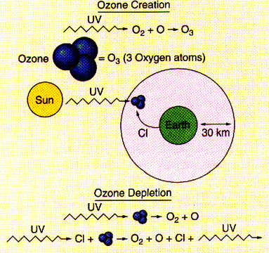
What role does ozone play?
the ozone layer in the atmosphere is being depleted by human-produced Cl-F carbons--less ozone in the atmosphere means more radiation penetrates the atmosphere and reaches the Earth
causing heating and increased radiation of life forms on Earth (e.g., skin cancer)
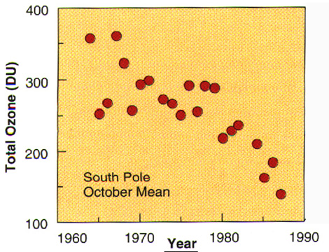
on Sep 7, 1996, the ozone hole over the Antarctic widened to a record size of 26 M km2--North America is 21 M km2
the increasing size of the ozone hole is a major concern
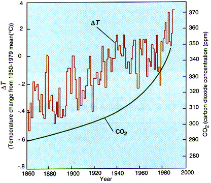
Is global warming really occurring? Fortune magazine says 'no'
View these measurements of temperature and atmospheric CO2, which provide credible evidence of warming and suggest a link with CO2
the temperature of the lower atmosphere has risen 0.5 °C in 100 years
it is predicted to rise at a faster rate of 1.2°C in the next 100 yr
global warming is also inferred to be changing the ranges of butterflies, which are moving farther and farther from the equator (Camille Parmesan, UCSB)
and, the peak time of plant growth (as measured by CO2 levels) is a week earlier than it was in 1975
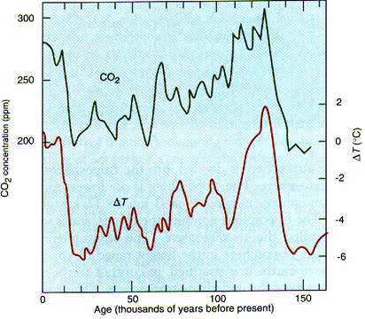
ice core records prove that there is a correlation between CO2 and temperature over the past 160,000 yr
So what?--that sounds like hardly anything
certain effects of global warming include climate changes and rising sea level
areas like the Nebraska grasslands could return to a desert ecology
if all icecaps melted today, the sea level would rise 60 m; this rise could occur abruptly if the submarine ice sheet of Antarctica becomes unstable
the entire population of New York City (equal to the entire population of Canada) would have to move to avoid drowning
the sea level is expected to rise by 1-2 meters per 100 yr for 200-500 yr
Problem: How to stop global warming?
Geological solution: Stop burning hydrocarbons and stop using Cl-F carbons
Political solution: use of Cl-F carbons is being curtailed in some countries
Practical solution: people will probably be forced to move unless they can impose their will on the people of other countries and reverse the long-term effects already in progress
Will hydrocarbons last forever?
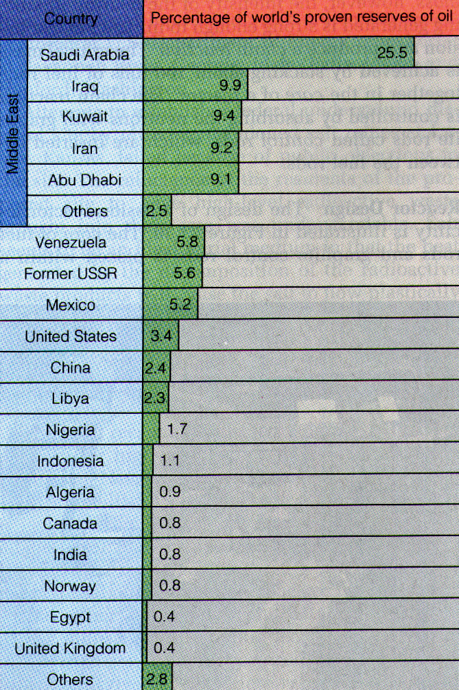
the per capita use of oil in the USA is 3800 L (we are 6% of the world population and account for 30% of oil consumption)
the rate of hydrocarbon extraction peaked in 1975
known reserves of oil will be gone by 2030, yet 95% of the world's energy requirements are currently drawn from oil
the US oil supply is 50-85 B barrels; we currently use 6 B barrels/yr, so domestic production can sustain us for 9-14 yr (i.e., until 2007-2012)--at current rates! Most of you will be 30-35 yr old then--younger than I am now
we in the US use 3 B barrels/yr of domestic oil and 3 B barrels/yr of foreign oil, so we might stretch it to 18-28 yr (until 2015-2025)--again at current rates
world supply of 700 B barrels; current use is 21 B barrels/yr, so the world oil supply is 33 yr (2030).
But what economic/political ramifications does this have for those of us in the US? What if other countries refuse to sell their oil or want to charge a high price? Will there be a war? Will we develop another energy source?
OPEC oil crisis of the 1970's
Gulf War of the 1990's
Check out the world population as of right now.
"Drink varnish and you'll have a lovely finish."
23. Plate Tectonics: Introduction May 30 to June 4
Reading: Chapter 11
What is continental drift?
continental drift is the idea that the continents moved about the Earth during the geologic past
What evidence is there for continental drift?
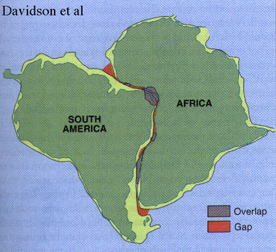
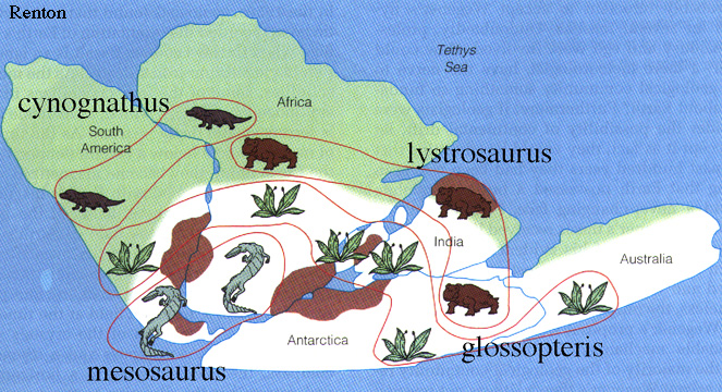
in about 1620 Francis Bacon noticed that South America and Africa could be fit together quite nicely.
in 1910 Alfred Wegner expanded on this and also noticed that there was evidence of glaciation in areas now near the equator and that the same large, land-going animals could be found in South America, Antarctica, and Africa; he hypothesized the existence of an earlier continent Gondwana
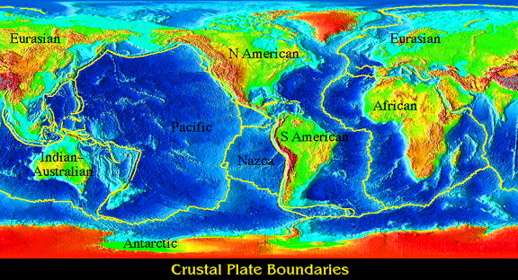
What is plate tectonics?
Plate tectonics is the geodynamical explanation for the motion of plates on and inside the Earth
View the motion of the plates over the last 200 Ma
What evidence is there for plate tectonics?
after WW II magnetometers looking for sunken ships found magnetic stripes on the seafloor that corresponded to seafloor topography
Fred Vine and Drummond Matthews proposed that the stripes resulted from different ages of seafloor produced at spreading centers; these data now exist for the entire planet
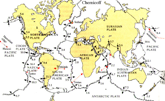
today we have direct measurements of the motions of plates (mm -> cm/year) as determined by global positioning system satellites
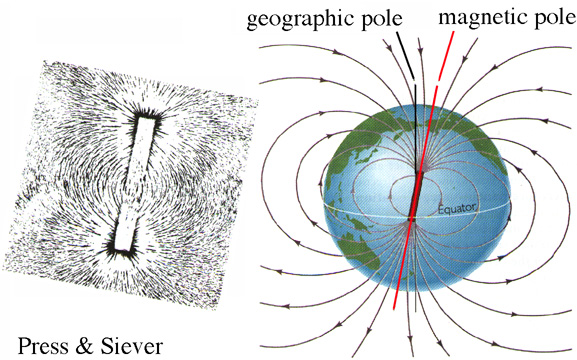
Why does the Earth have a magnetic field?
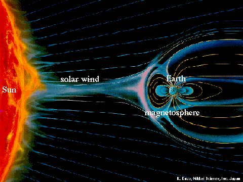
the magnetic field or magnetosphere is caused by electrons in the outer core moving in response to the motion of the Earth within the solar wind
the interaction between the solar wind and the magnetosphere causes the aurora borealis or northern lights
Is the magnetic field always the same?
when a magnetic reversals occurs, the entire magnetic field reverses polarity
Why should I care about the magnetic field?
aside from using the magnetic field for navigation purposes, the magnetic field also protects the Earth from the solar wind
we now have a satellite in a sentinel position between the Sun and Earth that is supposed to warn us about changes in the solar wind 1 hr before the solar wind hits the Earth
in 1989 a 90-sec burst of solar radiation collapsed the power grid in Quebec, costing $10 M
the problem of solar wind screwing up power grids is most acute in the eastern US because the predominant resistive granite bedrock means that the electrical effects of the solar wind are concentrated in power lines rather than being dissipated in the Earth
On January 6, 1997 a large coronal mass was ejected from the sun and reached Earth three days later, compressing the magnetosphere. Two days later, near the end of the storm, a Telstar satellite used for earthquake information failed, another satellite went into "safe" mode
What does the Earth look like internally?
Earth is 6370 km in radius
oceanic crust is 7 km thick, mafic (olivine + plagioclase)
continental crust is 35 km thick, felsic (plagioclase + quartz)
the mantle is ~3000 km thick, ultramafic (olivine + pyroxene)
the crust/mantle boundary is called the Mohoroviçic discontinuity
the outer core is a molten Fe-Ni alloy ~2000 km thick
the inner core is a solid Fe-Ni alloy ~1000 km in radius
"Never wrestle with a pig. You both get dirty but only the pig enjoys it."
24. Plate Tectonics: Birth of Oceanic Lithosphere May 30 to June 4
Reading: Chapter 11
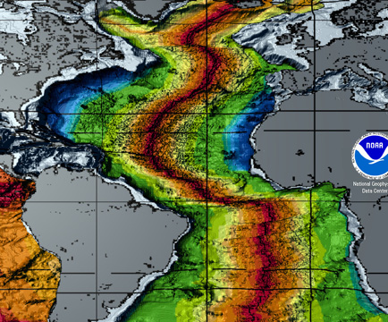
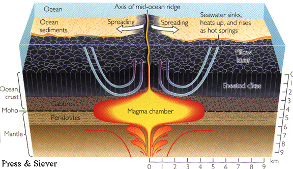
How does oceanic lithosphere form?
where the lithosphere rips apart, melted mantle material wells up toward the surface and crystallizes as oceanic crust
these mid-ocean ridges or spreading centers are simply tears in the lithosphere and can be identified by earthquakes
most spreading centers are 3-4 km below sea level
Iceland is the only example of a spreading center that is above sea level
How large are spreading centers and how fast do they produce rock?
length of spreading centers: 65,000 km--wrap around Earth about twice
rate of spreading: 1-10 cm/yr
volumetric production rate: 65,000 km *7 km * 3 cm/yr = 13 km3/yr or 20 M tonnes/yr
What causes plate tectonics?
plate motions are caused by differences in density
What causes differences in density in the Earth?
differences in temperature or rock type produce most of the differences in density in the Earth
density differences in the mantle arise because melted mantle is less dense than cold mantle
as a result, cold rock in the Earth wants to move downward in response to gravity and hot or melted rock wants to move up
convection is the boiling-coffee-pot like motion of rocks in the Earth
soft, but solid, rocks of the mantle are called asthenosphere and flow over geologic time
above the asthenosphere is the lithosphere, the even colder rocks of the mantle and the crust
the lithosphere is about ~100 km thick and rigid and strong compared to the asthenosphere
tectonic plates are different pieces of lithosphere
continental lithosphere 'floats' on the asthenosphere and is always less dense than the asthenosphere because it is felsic and contains lots of light elements
the elevations of ocean basins, continental interiors, and mountain belts are all determined by isostasy, or the buoyancy of vertical columns of lithosphere
oceanic lithosphere floats on the asthenosphere when it is young and hot
as oceanic lithosphere ages and cools, it becomes denser than asthenosphere and sinks (the sinking is best viewed by looking at the sinking of oceanic islands)--this is the primary cause of plate tectonics and convection
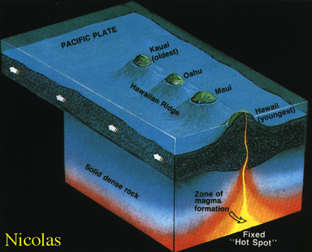
oceanic islands, such as Hawaii, are formed by hot spots, which burn holes through the plates traveling over them, leaving a record of plate motion in a hot spot track
"If you can smile when things go wrong then you have someone in mind to blame."
25. Plate Tectonics: Death of Oceanic Lithosphere and the Birth of Continents June 2
Reading: Chapter 11
Does oceanic lithosphere last forever?
No, in fact the oldest oceanic lithosphere is about 180 Ma
as oceanic lithosphere cools it becomes denser and depresses the underlying asthenosphere
eventually oceanic lithosphere sinks from 3 to 11 km beneath the waves
What evidence do we have of this?
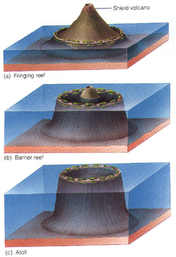
fringing reefs, barrier reefs, and atolls are most obvious example of the cooling and sinking of oceanic lithosphere, but bathymetric measurements are more quantitative
So what happens to old lithosphere?
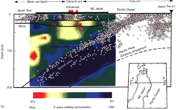
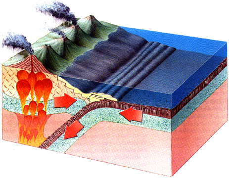
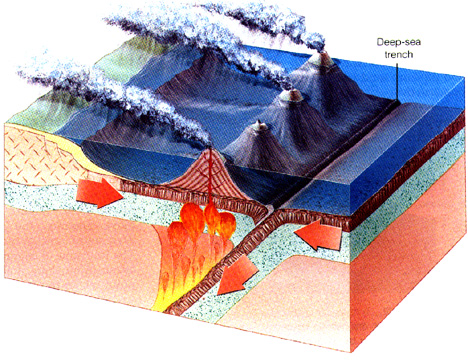
when oceanic lithosphere is old enough and dense enough it sinks into the asthenosphere, forming a subduction zone, which can be identified by earthquakes a the plate scale and at the local scale
in the subduction zone the basaltic oceanic crust undergoes a further change because the increasing pressure, and it changes to blueschist and eclogite
How do continents get built?
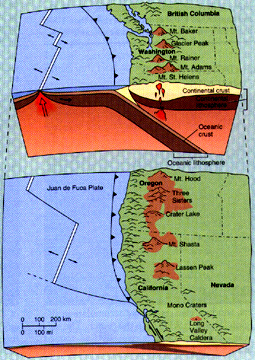
when oceanic lithosphere sinks into the mantle, it returns volatiles (e.g., H2O, K) to the mantle; the introduction of volatiles into the mantle causes the mantle to melt, producing magmatism. Magmatic arcs along the edges of continents are called continental margin arcs, whereas magmatic arcs within oceans are called intraoceanic arcs
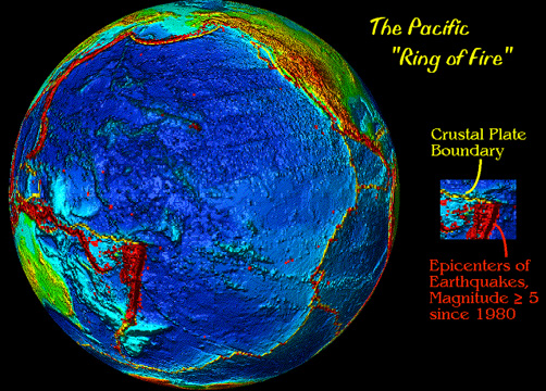
What is the Ring of Fire? Why do I care?
the Ring of Fire is the ring of arc volcanoes and earthquakes surrounding the Pacific Ocean
living along the Ring of Fire is dangerous
"The careful application of terror is also a form of communication."
26. Plate Tectonics: Mountain Building June 4
Reading: Chapter 11
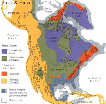
All continents consist of undisturbed core areas called cratons and surrounding orogens or mountain belts
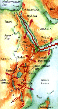
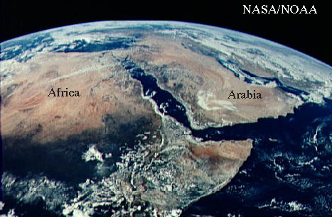
Continents are torn apart along rift zones like the East African Rift or the Red Sea.
What makes mountains? (See the Andes)
the main causes of mountain building (orogeny) are faulting and folding in response to plate motions
What are some classic types of mountain belts?
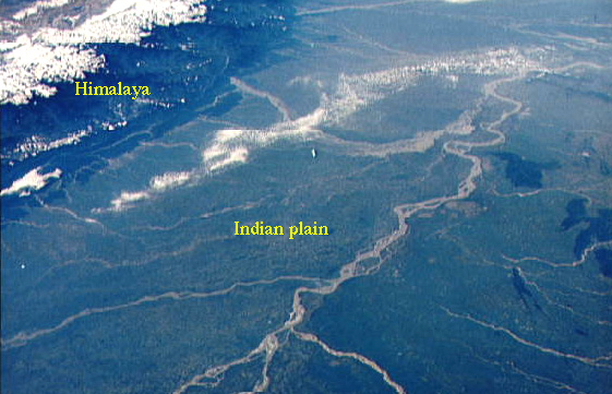
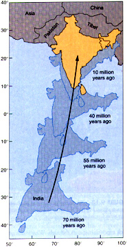
Himalaya are an active continental collision zone
View the motion of India prior to collision with Eurasia
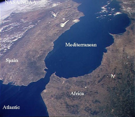
The continental collision forming the Alps has also caused the Mediterranean to dry up; look at this picture and see why that was possible
How can you tell how old a mountain is?
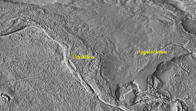
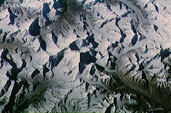
erosion tears mountains down, so old mountains are short, young mountains are tall; look at North America, where you can compare the Appalachians and the young Sierra Nevada; more impressive is the incredible topography around Mt Everest.
Appalachians are a Paleozoic continental collision zone
Rocky Mountains are an intracontinental mountain belt
What is the plate tectonic history of California?
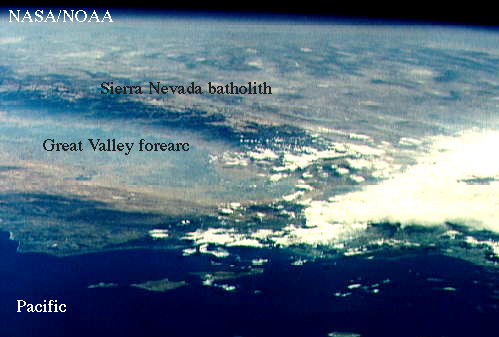
Sierra Nevada: Paleozoic passive margin, Mesozoic convergent margin; now an active continental margin exists north of here in the Cascades
View the motion of the plates over the last 200 Ma
ThatŐs all folks--thanks for being in the class!