Geology 2 Spring 1997
Name:
Lab day & time:
PRELAB #8. PLATE TECTONICS
This prelab assignment is due at the beginning of your lab session. You will not be allowed to participate in the lab if you have not completed this prelab exercise.
Be sure to bring your textbook, Geology by Chernicoff, with you to the lab as we will be using several of its the maps and diagrams. You will also need a few sharpened pencils with erasers, and a hand calculator would be useful.
Read pages 10-19 in Chernicoff and study figures 1-6 through 1-14. Answer the following.
What two layers of the Earth (e.g., crust, outer core, etc.) are included as parts of the lithosphere and thus move as parts of the rigid plates?
Name the process by which new ocean floor is created at divergent plate boundaries.
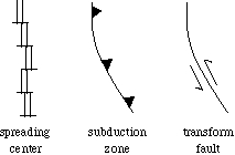
What is the symbol used to show the locations of these features on maps such as fig. 1-8?
If you could dive down to the ocean floor in search of one of these plate boundaries, what geologic features might you observe that would tip you off that you had found it?
The Cocos plate is near which continental geographic location(s)?
The Nazca plate is near which continental geographic location(s)?
The East Pacific Rise is the spreading center that separates the Pacific plate from the Cocos, Nazca, and Antarctic plates. Does it lie in the center of the Pacific ocean basin?
Does it extend far into the north Pacific ocean basin?
At what location does it intersect the rim of North America?
Name the process by which ocean floor is destroyed at convergent plate boundaries.
What is the symbol used to show the locations of these features on maps such as fig. 1-8?
If you explored Alaska in search of this kind of plate boundary, what geologic features might you observe that would tip you off that you were near one?
Name the process by which continents are sutured together and shortened at convergent plate boundaries.
What is the symbol used to show the locations of these features on maps such as fig. 1-8?
If you explored southeast Asia in search of this kind of plate boundary, what geologic features might you observe that would tip you off that you had found it?
Name the type of plate boundary where plates slide past one another, neither creating nor destroying surface area. plateSymbolsspreading centers. What is the symbol used to show the locations of these features on maps such as fig. 1-8?
If you explored California in search of this kind of plate boundary, what geologic features would tip you off that you had found it?
Refering to the map in Chernicoff, fig. 1-8, draw the major plate boundaries using their symbols:
When drawing the plate boundaries, be neat and pay attention to details. For example: Notice that plate boundaries are continuous; they don't stop or start. In other words, every plate is completely surrounded by plate boundaries. Notice and learn which direction the teeth point on the subduction zones. Notice which of the sea-floor spreading ridges are centered in their ocean basins and which are not. You don't need to include every transform fault along the spreading centers.