Geology 2 Spring 1997
Name:
Lab day & time:
PRELAB #6. GEOLOGIC MAPS AND CROSS-SECTIONS OF THE SANTA BARBARA AREA
This prelab assignment is due at the beginning of your lab session. You will not be allowed to participate in the lab if you have not completed this prelab exercise. In this lab you will be examining our local rocks as they are depicted on geologic maps and cross-sections. Read about geologic maps in Chernicoff Appendix D, pages A-6, A-7, read the attached pages about our local geologic history, and study the local stratigraphic section.
Answer the following questions.
On the geologic map on Chernicoff p. A-7, what formation is
represented by the symbol Tmq?
What is the age of Tmq?
What is the composition of Tmq?
What formation is found in outcrops on the tops of the hills?
Scan the rock descriptions. Are these igneous, metamorphic or sedimentary rocks?
Use the material below to answer the following questions about Goleta-Santa Barbara area geology.
What is a "formation" and how are formations named?
In the stratigraphic column, the graphical representation of the formations has an irregular left-side edge. What do these irregularities depict?
According to the stratigraphic column...
Which is older, the Monterey Formation or the Sespe Formation?
Are our local Cenozoic (Tertiary + Quaternary) aged formations made up of igneous, metamorphic or sedimentary rocks?
Which of the formations were deposited on land, i.e., are "non-marine" [(N) on the column]?
Which time periods are represented by these non-marine rocks? (i.e., when was there dry land here?)
Which formations include beds of conglomerate or breccia?
Which time periods included conglomerate/breccia deposition?
What conditions are implied by the deposition of these types of rocks?
Review of Strike and Dip measurements. Describe in words the strike and dip represented by the symbol:
GEOLOGY OF THE GOLETA - SANTA BARBARA REGION
Introduction
In the Geologic Maps Lab and on the Santa Ynez Mountains Field Trips we will study our local Goleta - Santa Barbara geology. In these studies we shall be using geologic maps, geologic cross-sections and a stratigraphic column.
Geologic Maps
Geologic maps show the distribution of rock types in an area and the relationships between them. For convenience, the rocks are grouped into packages called "formations"; the boundaries between formations are called "contacts". Each colored area on the map represents a formation or a "unit" within a formation which is an easily recognizable package of rocks. The geologist may choose to group or subdivide rock units appropriate to the scale at which she/he is mapping. For example, the Eocene rocks that are assigned seven different colors on the Santa Barbara map are given a single color on the California state geologic map.
Geologists create their informative (and colorful) maps by plotting geological information onto topographic maps. The creation of a geologic map is a very arduous task, involving years of field work and considerable geologic insight. The maps we will be using were created and refined over many decades of work by Mr. Thomas Dibblee, California's foremost geologic mapper and a long time Santa Barbara-area resident.
Geologic Cross-sections
A geologic cross-section displays geologic features in a vertical section As an analogy, think of a layer cake. When you look at the cake from above, all you can see is the frosting; but if you slice the cake and look at cut surface, the layered structure of the cake is revealed.
Geologic cross-sections are constructed on a vertical plane. First, the topographic profile is constructed, then surface observations from the geologic map such as formation contacts, strikes and dips, fold axes, and fault traces are used as clues to construct a model of the subsurface geometry. These cross-sections are always interpretations, constructed by extrapolating the surface observations to depth in a logical (but not necessarily true) way. They are the geologist's best guess at what we would see if we could slice into the earth and look.
Stratigraphy and stratigraphic columns.
Stratigraphy is the study of the vertical arrangement of the particular rocks in a given area. For convenience in mapping an area, geologists group the local rocks into stratigraphic packages called
formations. Recognition of individual formations is somewhat arbitrary, but criteria include appearance (rock types and textures, outcrop characteristics and geometries), similar formative processes, and lateral continuity. A formation is usually considered to be a unit which is mappable. Formations are commonly named for the locale where they were first mapped and described.
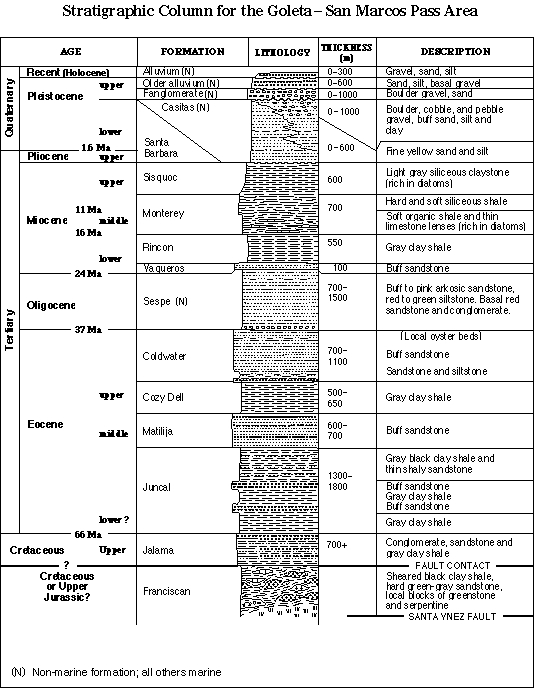
The stratigraphy of an area can be graphically represented by a
stratigraphic column, such as the one on a following page for the San Marcos Pass region. This stratigraphic column contains several types of information. The various formation names and a graphical representation of their lithologic characteristics are given in the center of the table. The irregular left edge of the central column is a representation of the relative strength or weakness of each layer and this, in turn, is an indication of which layers will tend to form peaks and cliffs and which will form saddles and slopes. Thickness and some general descriptive characteristics are given in the right columns. The far left column gives the age of the formations on the relative geologic time scale. Older formations are lower on the column.
A Geologic History of the San Marcos Pass Area
This is a brief geologic history of the San Marcos Pass area of the Santa Ynez Mountains. The information given is for that particular locality but the broad story is true for the entire south coast region. You will find it easier to absorb the information if you keep track of the formations on the stratigraphic column as you read through the history.
The oldest rocks in the San Marcos Pass area are parts of the
Franciscan Formation. The Franciscan consists of a highly mixed assemblage of deep water sedimentary rocks including cherts and greywacke sandstones, plus altered basalt and serpentinite. The Franciscan sedimentary rocks were deposited on the deep ocean floor and the Franciscan basalts and serpentinites are pieces of the oceanic crust. These rocks were deformed, stacked up, and transferred to the edge of North America when their oceanic plate was subducted beneath the rim of the continent. In this area, the formation is Jurassic to Cretaceous in age.
Eocene rocks are all marine and are well-represented in the area, attaining a thickness of over 3000 m (10,000 ft). Most of the Santa Ynez mountain range north of Goleta and Santa Barbara is carved from these rocks, and the more resistant sandstones of this age form nearly all the higher peaks. The
Juncal, Matilija, and Cozy Dell Formations are all clastic rocks which were deposited in deep ocean water on the continental shelf, in the form of submarine fans. Toward the top of the Eocene section is the
Coldwater Formation. The Coldwater is made up of about 80% arkosic sandstone and 20% siltstone and shale. Nearshore conditions are indicated in this time by oyster beds and other marine fossils, with occasional streaks of red shale, presumably washed into the shallow marine waters from nearby land.
In Oligocene time, the sea withdrew from the area, leaving a broad coastal plain on which were deposited the conglomerates, sandstones, and silts of the
Sespe Formation. The Sespe is coarsest near its base, where conglomerates are interbedded with sandstones. The presence of conglomerates suggests that an eroding highland was relatively nearby. The Sespe beds were deposited in a river-flood plain or deltaic depositional environment. Several lines of evidence suggest that the Sespe is a non-marine unit. Its red color comes from the oxidation of iron within the sediment, which generally takes place in terrestrial environments where sediments are exposed to the air in alternating wet and dry seasons. The arrangement of sedimentary structures in the Sespe is best interpreted as representing a series of non-marine environments. Finally, marine fossils, such as those seen in the Coldwater, are conspicuously lacking in the Sespe. Vertebrate fossils, such as horse teeth, have been found in the Sespe, but are not proof of a non-marine setting since they could have been washed offshore.
Toward the end of the Oligocene, the sea again spread over the area. The first marine unit is the
Vaqueros Formation, which contains abundant broken shell material, and suggests deposition near a gravelly shoreline. The Vaqueros is covered by a series of marine siltstones and shales which indicate deeper water conditions again, starting with the
Rincon Shale, a monotonous gray clay shale. Above the Rincon is the
Monterey Formation, also a shale but very rich in organic debris, especially the microscopic silica shells of one-celled plants called diatoms. The organic molecules in this debris have subsequently been altered to oil and gas, hence all the oil platforms and the oil and tar seeps in our area. In the Goleta area (and the eastern campus bluffs) the Monterey formation grades upward into the
Sisquoc Formation, a gray mudstone, also very rich in diatoms.
In Quaternary time, the Coast Range orogeny shortened and elevated the Santa Ynez mountains. Through a series of faulting and folding events, the formations described above were deformed into their current homoclinal (uniformly dipping) geometry. They have since been partially eroded, the resulting debris forming alluvial fans ("fanglomerates") and other deposits ("alluvium") at the top of the section.
There is compelling evidence that uplift and tectonic deformation continues today. Earthquakes are common, showing tectonic stress. Recent beach terraces and river bed sediments lying above modern terraces and river sediments also demonstrate active uplift. Near Santa Barbara, Sespe beds can be found that are in fault contact with Pleistocene units, showing that faulting occurred after the deposition of the Pleistocene sediments, i.e., very recently.