Geology 2 Spring 1997
Name:
Lab day & time:
PRELAB #4. BEACH PROCESSES AND FEATURES
It is especially important that you do a good job on this prelab since we will be doing our work on the beach in a noisy, confusing environment.
Read about beach processes and shorelines in Chapter 17 in Chernicoff, the supplementary material below, and review your lecture notes from the movie Beach, River of San. Complete the exercises, below, before coming to lab. For the lab session:
Meet at the beach-access stairway east of Santa Cruz Hall;
Bring prelab, extra paper, pencils with erasers, and a clipboard or hard surface to write on;
Wear comfortable, warm clothes and old shoes or flip-flops that are good for walking and that won't be ruined if you get tar or water on them.
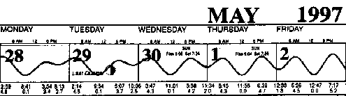
1. Tides and reading tide tables.
Below, find the tide tables in numeric and graphical form.
The numeric table was scanned from a standard tide booklet available (cheap or free) from any fishing or surf shop. When will your lab section be starting its beach walk?
Date
Day
Time
On the numeric tide table, find and underline the high and low tides nearest your section meeting time. On the graphical tide calendar, mark those same high and low tides and also the tide at the actual meeting time.
As an example, this information has been marked for an imaginary beach picnic. Will there be plenty of sandy beachface exposed for partying?
Fill in the tide information requested at the end of this lab.
| |
Low |
|
Tide |
------- |
|
High |
|
Tide |
|
| Date |
A.M. |
Ht. |
P.M. |
Ht. |
|
A.M. |
Ht. |
P.M. |
Ht.
|
| Mon Apr 28
| 9:07 |
0.1 |
8:39 |
2.6 |
|
1:25 |
4.6 |
4:20 |
3.3
|
| Tues Apr 29
| 10:20 |
0.1 |
10:32 |
2.4 |
|
2:40 |
4.3 |
5:33 |
3.6
|
| Wed Apr 30
| 11:27 |
0.1 |
--- |
--- |
|
4:13 |
4.2 |
6:24 |
4.1
|
| Thur May 1
| 12:00 |
1.9 |
12:24 |
0.0 |
|
5:41 |
4.2 |
7:05 |
4.5
|
| Fri May 2
| 1:04 |
1.2 |
1:13 |
0.0 |
|
6:54 |
4.4 |
7:43 |
5.0
|
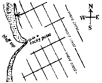
2. Refraction of waves approaching the shore.
Read about the refraction (bending) of waves as they enter shallow water and break on the beach and read about longshore currents and longshore drift of sand. To the right is a diagrammatic map of wave crests approaching a hypothetical coast line.
Finish drawing the wave crests all the way to the beach, showing how they bend as they enter the shallow water and encounter the beach.
Finish drawing the arrows up to the shore to show the direction of wave travel. (They also should curve as they approach the shore.)
What direction would you predict for the long shore drift on this beach?
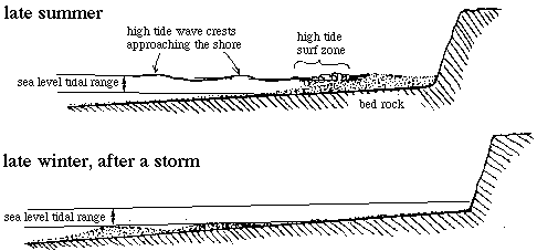
3. Seasonal beach profiles, wave-cut terraces, and beach cliff erosion.
Our local beaches consist of loose sand lying upon a bedrock "wave-cut terrace". Most of the time, incoming waves simply shift the sand around, but occasionally large winter storm waves shift most of the sand away from the beach to offshore bars. At these times, the waves resume their erosive work on the bedrock, smoothing the terrace surface and extending the terrace by eroding material from the bases of the cliffs. During the beach walk we will note the state of the sand beach on the present terrace, examine an ancient wave-cut terrace that has been uplifted by tectonic motion, and observe some results of beach cliff erosion.
In lecture, we saw the movie Beach, River of Sand which discussed the onshore-offshore shifting of beach sand during the different seasons.
Below are two beach profiles, drawn for late summer and late winter. On each profile,
label (1)
sea cliff,
(2)
wave-cut terrace,
(3)
offshore bar(s),
(4)
beach face (swash zone),
(5)
berm,
and (6)
back beach (overwash area), if any. A water surface profile has been drawn on the upper diagram for summer high tide.
Draw the water surface profile for winter high tide and
label the surf zone
4. Changes in global sea level.
In the recent geological past, global sea level has risen and fallen many times, changing in elevation/depth by as much as 200 meters. These rises and falls of sea level are directly correlated to the waxing and waning of continental glaciers during the ice ages because the water that is stored on the land as ice has been removed from the world oceans. Thus, during glacial maxima global sea level was lowest. Right now we are in a glacial minimum, an "interglacial period" (the ice sheets have melted off of Canada and Asia), and global sea level is quite high.
Below find the global sea level curve graphing oscillations in sea level for the last 160,000 years and a more detailed version of this curve for the last 20,000 years.
GLOBAL SEA LEVEL FLUCTUATIONS THROUGH TIME
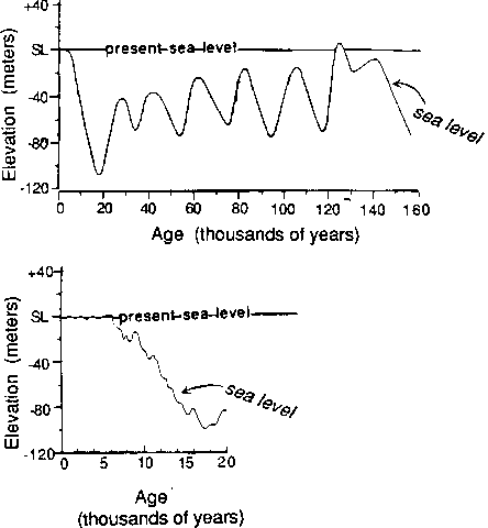
Using these curves, answer the following questions.
a. In the last 160,000 years was sea level ever higher than now? When? years ago.
b. Find and mark the part of the curve representing the highstand in sea level that occurred about 40,000 years ago. What was the height of sea level at that time? approx. m
Compared to present sea level, was it (circle one) higher or lower?
What do you think was happening in the earth's glacial cycle at that time?
c. Find and mark the part of the curve representing the high stand in sea level that occurred about 60,000 years ago. What was the height of sea level during that time? approx. m
You will use this information on the next page.
d. On the right-hand diagram, find and mark the part of the curve representing the most recent lowstand in sea level. What was the height of sea level at that time? approx. m
When did this lowstand end and sea level start rising? approx. years ago.
What do you think was happening in the earth's glacial cycle during the time of this low sea level stand?
e. According to the right hand diagram, how long ago did sea level arrive at its present level? approx. years ago.
5. Using old wave-cut terraces to estimate tectonic uplift rates of the Rincon.
Since ocean waves intersect the shore and do their erosive work at sea level, a marine wave-cut terrace forms an excellent geological record of sea level at the time the terrace was cut. Thus, we can use ancient terraces to detect ancient relative sea levels. In any given region, changes in terrace level will reflect both changes in global sea level and changes in local land elevation caused by local tectonic movements. If we can subtract the effects of the global changes, we can measure the rates of local tectonic uplifts or down drops.
The California coast is tectonically very active. In fact, the cliffs along the Rincon, along Highway 101 between Carpinteria and Ventura, are presently being lifted at some of the fastest rates in the world. The highway was built on an uplifted terrace that was cut within the last few thousand years (after sea level stabilized at its present height). Several other wave-cut notches can be seen farther up the hillsides, and the top surfaces of these bluffs were cut during the highstand of sea level that occurred about 60,000 years ago. The highest parts of these top surfaces now stand about 250 meters above present sea level.
What was the height of sea level 60,000 years ago? approx m below present sea level.
Adding this to 250 m, the total uplift of that terrace was about m (= mm)
Calculate the average uplift rate of the Rincon during
the last 60,000 years. mm / 60,000 yr = mm/yr
The world's highest mountains (some Himalayan peaks) are nearly 8 km high. At the Rincon uplift rate and assuming no erosion, how many millions of years would it take to uplift the Rincon bluff to 8 km elevation? (Notice that mm/yr is the same number as km/m.y.) m.y.
Show your calculation:
For comparison, it probably actually took about 10 million years for the Himalayan peaks to reach their height.
6. Sea cliff Retreat. Every house on the bluff-top of Del Playa in Isla Vista, and all along the California sea coast, is threatened by the continual erosion and retreat of the coastal cliffs. Left to its own devices, a sea cliff may retreat at an average rate of ten centimeters (or more) per year. This rate predicts that every bluff-top house on D.P. will fall into the sea during the next century, many considerably earlier than that.
There are three main mechanisms of cliff erosion in California: (1) wave action, (2) landslides, and (3) water flow over and through the cliff rocks.
By far the most active of these processes is the erosion at the base of the cliff by waves during stormy years (1). Erosion at its base undermines the cliff until it falls in a (2) landslide. The relatively soft sedimentary rocks that make up the cliffs along the California coast have been historically prone to sudden, catastrophic landslides, including a number of damaging ones in Santa Barbara. (3) When water washes over the bluff top it will erode it. When it percolates down through, it will commonly dissolve the chemical cement holding the rock together, weakening it, and will seep out along layers in the cliff face and carry sediment with it. Irrigation above or the installation of septic systems can significantly worsen the problem.
Various human-engineered structures have been emplaced in efforts to reduce the rate of cliff retreat. These measures include building sea-walls at the base of the cliff, placing gabions (rock-filled baskets) or loose rock at the base, guniting (spraying concrete over) the face, or even placing sheet plastic over the cliff. Unfortunately, these heroic measures have proven to be short-term at best and the natural erosion continues apace.
7. Beach Tar and natural seeps. During the beach walk you are likely to get tar on your shoes. Tar and oil naturally seep out of the rocks along this coast. Impressive cascades of tar can be seen oozing from the cliffs of Moore Mesa. (This tar cascade can be reached by walking the beach eastward past Goleta Beach and wading across the mouth of Goleta slough.) Furthermore, the hole in the ground presently occupied by the campus lagoon is a man-made depression, created by excavation of an asphalt mine. The tar on the beach around campus point washes ashore after bubbling out of underwater seeps just offshore.
Information for your lab meeting time.
Section meeting time Day Date
Times and heights of nearest low and high tides: ft ft
Approximate tide height above mean low tide at start of your section meeting: ft
Tidal range for last few days: to ft
Weather today Recent storms?